
Magnitude |
:3.5 |
| Date & Time (UTC) | 2010-09-18 13:17:07.7 |
| Date & Time (Local) | 1389/6/27 17:47:07.7 |
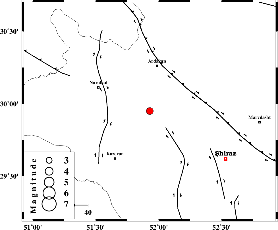
| Location | Lat:29.95 Lon: 51.93 |
| Region | Fars Province, 35 km South of Ardakan |
Nearest Cities |
|
| 28 km North East of Nodan, Fars Province | |
| 31 km South of Bahrghan, Fars Province | |
| 33 km North East of Seyyed hasan, Fars Province | |
| 35 km South of Ardakan, Fars Province | |
| 41 km North of Kalani, Fars Province | |
| Depth | 14 km |
| Agency | |
Faults within 150 km: |
|
| KAREBASS_F (Length: 98 km) , Distance to epicenter: 17 km | |
| KAZERUN_F (Length: 96 km) , Distance to epicenter: 33 km | |
| HZF3 (Length: 197 km) , Distance to epicenter: 33 km | |
| Number of Phases | 4 |
| RMS | 0 |
| Number of Stations | 5 |
| Error in Latitude | >5.5 km |
| Error in Longitude | 3.8 km |
| Error in Depth | 13.5 km |
Download waveform in seisan format
to download seisan software Click here
to access information about IIEES stations Click here
Amplitude | ||||||||
| UID | Agency | Station | Component | Amplitude | Period | Arrival Time | Proccessing Time | Signal Clip |
| 70590 | IIEES | GHIR | E | 319.5 | 0.85 | 2010-09-18 13:18:20 | 2010-09-18 01:32:00 | n |
| 70591 | IIEES | GHIR | N | 309.3 | 1.56 | 2010-09-18 13:18:28 | 2010-09-18 01:32:00 | n |
| 70592 | IIEES | SHGR | N | 162.3 | 0.58 | 2010-09-18 13:18:58 | 2010-09-18 01:32:00 | n |
| 70593 | IIEES | SHGR | E | 204.6 | 0.29 | 2010-09-18 13:19:04 | 2010-09-18 01:32:00 | n |
| 70594 | IIEES | KRBR | E | 39.3 | 1.88 | 2010-09-18 13:19:36 | 2010-09-18 01:32:00 | n |
| 70595 | IIEES | KRBR | N | 45.6 | 0.23 | 2010-09-18 13:19:42 | 2010-09-18 01:32:00 | n |
Phase | ||||||||||||
| Agency | Station | Component | Phase Type | Phase Quality | First Motion | Observed Arrival Time | Time Residual | Loc. Flag | Input Weight | Distance | Azimuth | |
| IIEES | AHRM | Z | Pg | E | 2010-09-18 13:17:30 | 0 | y | 135 | 207 | |||
| IIEES | GHIR | Z | Pg | E | 2010-09-18 13:17:42 | 0 | y | 211 | 151 | |||
| IIEES | NASN | Z | Pn | E | 2010-09-18 13:17:56 | 0 | y | 326 | 15 | |||
| IIEES | KRBR | Z | Pn | E | 2010-09-18 13:18:13 | 0.1 | y | 466 | 88 | |||