
Magnitude |
:2.8 |
| Date & Time (UTC) | 2010-09-13 13:41:38.8 |
| Date & Time (Local) | 1389/6/22 18:11:38.8 |
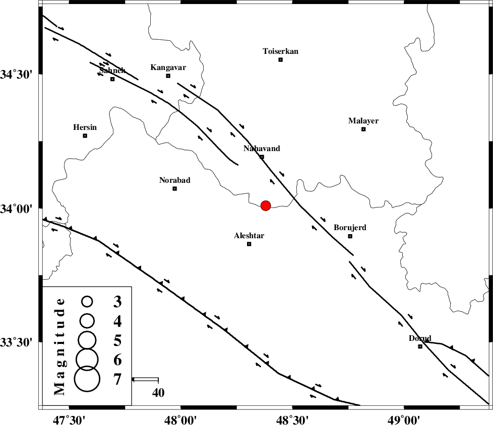
| Location | Lat:34.01 Lon: 48.38 |
| Region | Hamedan Province, 20 km South of Nahavand |
Nearest Cities |
|
| 11 km of Babaqasem, Hamedan Province | |
| 17 km West of Jaefarabad, Lorestan Province | |
| 17 km North of Aleshtar, Lorestan Province | |
| 18 km North East of Dehrahim, Lorestan Province | |
| 20 km South of Nahavand, Hamedan Province | |
| Depth | 32 km |
| Agency | |
Faults within 150 km: |
|
| NAHAVAND_F (Length: 102 km) , Distance to epicenter: 14 km | |
| SAHANEH_F (Length: 77 km) , Distance to epicenter: 20 km | |
| DORUD (Length: 100 km) , Distance to epicenter: 41 km | |
| Number of Phases | 5 |
| RMS | 0 |
| Number of Stations | 3 |
| Error in Latitude | >2.7 km |
| Error in Longitude | 1.8 km |
| Error in Depth | 3.3 km |
Download waveform in seisan format
to download seisan software Click here
to access information about IIEES stations Click here
Amplitude | ||||||||
| UID | Agency | Station | Component | Amplitude | Period | Arrival Time | Proccessing Time | Signal Clip |
| 70410 | IIEES | KHMZ | N | 124.3 | 0.44 | 2010-09-13 13:42:24 | 2010-09-13 02:04:00 | n |
| 70411 | IIEES | KHMZ | E | 127 | 0.4 | 2010-09-13 13:42:27 | 2010-09-13 02:04:00 | n |
| 70412 | IIEES | SNGE | N | 271.2 | 0.44 | 2010-09-13 13:42:29 | 2010-09-13 02:04:00 | n |
| 70413 | IIEES | SNGE | E | 224.2 | 0.52 | 2010-09-13 13:42:30 | 2010-09-13 02:04:00 | n |
| 70414 | IIEES | ASAO | N | 115.9 | 0.88 | 2010-09-13 13:42:35 | 2010-09-13 02:04:00 | n |
| 70415 | IIEES | ASAO | E | 79.9 | 0.44 | 2010-09-13 13:42:38 | 2010-09-13 02:04:00 | n |
Phase | ||||||||||||
| Agency | Station | Component | Phase Type | Phase Quality | First Motion | Observed Arrival Time | Time Residual | Loc. Flag | Input Weight | Distance | Azimuth | |
| IIEES | KHMZ | Z | Pg | E | 2010-09-13 13:42:03 | -0.1 | y | 149 | 101 | |||
| IIEES | KHMZ | E | Sg | E | 2010-09-13 13:42:21 | 0.1 | y | 149 | 101 | |||
| IIEES | SNGE | Z | Pg | E | 2010-09-13 13:42:04 | 0 | y | 153 | 322 | |||
| IIEES | ASAO | Z | Pn | E | 2010-09-13 13:42:05 | 0 | y | 163 | 68 | |||
| IIEES | ASAO | N | Sg | E | 2010-09-13 13:42:25 | 0 | y | 163 | 68 | |||