
Magnitude |
:2.6 |
| Date & Time (UTC) | 2010-09-01 19:33:39.6 |
| Date & Time (Local) | 1389/6/11 00:03:39.6 |
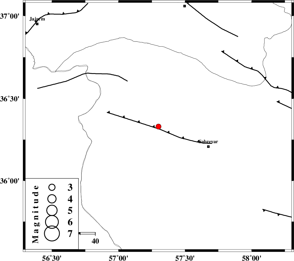
| Location | Lat:36.33 Lon: 57.3 |
| Region | Khorasan(center) Province, 37 km North-West of Sabzevar |
Nearest Cities |
|
| 11 km North of Rivand, Khorasan(center) Province | |
| 21 km North East of Sadkharu, Khorasan(center) Province | |
| 31 km South West of Void, Khorasan(center) Province | |
| 34 km South East of Abuchenari, Khorasan(center) Province | |
| 36 km North West of Sabzevar, Khorasan(center) Province | |
| Depth | 19 km |
| Agency | |
Faults within 150 km: |
|
| SABZEVAR_F (Length: 81 km) , Distance to epicenter: 2 km | |
| JOGHATAI_F (Length: 70 km) , Distance to epicenter: 37 km | |
| RIVAND_F (Length: 70 km) , Distance to epicenter: 66 km | |
| Number of Phases | 6 |
| RMS | 0.1 |
| Number of Stations | 5 |
| Error in Latitude | >2.4 km |
| Error in Longitude | 4 km |
| Error in Depth | 9.3 km |
Download waveform in seisan format
to download seisan software Click here
to access information about IIEES stations Click here
Amplitude | ||||||||
| UID | Agency | Station | Component | Amplitude | Period | Arrival Time | Proccessing Time | Signal Clip |
| 69754 | IIEES | BJRD | E | 78.5 | 0.44 | 2010-09-01 19:34:29 | 2010-09-01 08:21:00 | n |
| 69755 | IIEES | MRVT | E | 61.1 | 0.48 | 2010-09-01 19:34:36 | 2010-09-01 08:21:00 | n |
| 69756 | IIEES | TABS | N | 36.8 | 0.64 | 2010-09-01 19:35:15 | 2010-09-01 08:21:00 | n |
Phase | ||||||||||||
| Agency | Station | Component | Phase Type | Phase Quality | First Motion | Observed Arrival Time | Time Residual | Loc. Flag | Input Weight | Distance | Azimuth | |
| IIEES | SHRO | Z | Pg | E | 2010-09-01 19:33:59 | 0 | y | 121 | 253 | |||
| IIEES | BJRD | Z | Pg | E | 2010-09-01 19:34:04 | 0.1 | y | 152 | 4 | |||
| IIEES | MRVT | Z | Pg | E | 2010-09-01 19:34:08 | -0.2 | y | 182 | 324 | |||
| IIEES | MRVT | N | Sg | E | 2010-09-01 19:34:30 | 0 | y | 182 | 324 | |||
| IIEES | TABS | Z | Pn | E | 2010-09-01 19:34:24 | 0.1 | y | 298 | 183 | |||
| IIEES | SHRT | Z | P | E | 2010-09-01 19:34:36 | -0.1 | y | 404 | 137 | |||