
Magnitude |
:3.2 |
| Date & Time (UTC) | 2010-09-01 03:46:06.1 |
| Date & Time (Local) | 1389/6/10 08:16:06.1 |
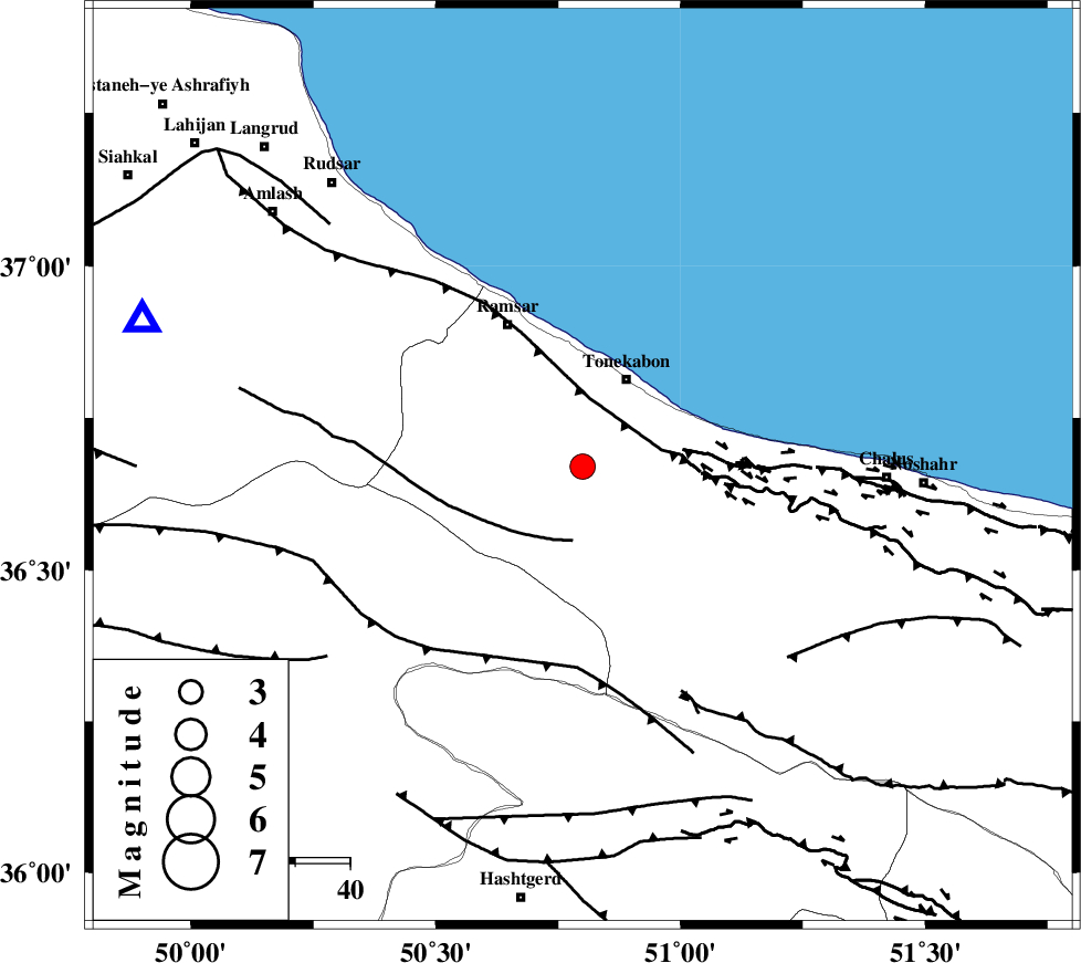
| Location | Lat:36.67 Lon: 50.8 |
| Region | Mazandaran Province, 18 km South of Tonekabon |
Nearest Cities |
|
| 14 km South of Soleymanabad, Mazandaran Province | |
| 15 km South of Khorramabad, Mazandaran Province | |
| 17 km West of Kanza, Mazandaran Province | |
| 18 km South of Tonekabon, Mazandaran Province | |
| 28 km West of Abbasabad, Mazandaran Province | |
| Depth | 14 km |
| Agency | |
Faults within 150 km: |
|
| KHAZAR_F (Length: 523 km) , Distance to epicenter: 13 km | |
| BONAN_F (Length: 74 km) , Distance to epicenter: 14 km | |
| N_ALBORZ_F (Length: 360 km) , Distance to epicenter: 15 km | |
| Number of Phases | 8 |
| RMS | 0.3 |
| Number of Stations | 8 |
| Error in Latitude | >9.5 km |
| Error in Longitude | 8.1 km |
| Error in Depth | 8.8 km |
Download waveform in seisan format
to download seisan software Click here
to access information about IIEES stations Click here
Amplitude | ||||||||
| UID | Agency | Station | Component | Amplitude | Period | Arrival Time | Proccessing Time | Signal Clip |
| 69721 | IIEES | THKV | N | 2368.6 | 0.29 | 2010-09-01 03:46:34 | 2010-09-01 04:10:00 | n |
| 69722 | IIEES | THKV | E | 2472.1 | 0.43 | 2010-09-01 03:46:34 | 2010-09-01 04:10:00 | n |
| 69723 | IIEES | CHTH | N | 100 | 0.12 | 2010-09-01 03:46:34 | 2010-09-01 04:10:00 | n |
| 69724 | IIEES | ZNJK | N | 258.8 | 0.13 | 2010-09-01 03:47:02 | 2010-09-01 04:10:00 | n |
Phase | ||||||||||||
| Agency | Station | Component | Phase Type | Phase Quality | First Motion | Observed Arrival Time | Time Residual | Loc. Flag | Input Weight | Distance | Azimuth | |
| IIEES | THKV | Z | Pg | E | 2010-09-01 03:46:21 | 0.5 | y | 83.7 | 175 | |||
| IIEES | CHTH | Z | Pg | E | 2010-09-01 03:46:21 | 0.1 | y | 89.1 | 161 | |||
| IIEES | DAMV | Z | Pg | E | 2010-09-01 03:46:31 | -0.2 | y | 156 | 137 | |||
| IIEES | ZNJK | Z | Pg | E | 2010-09-01 03:46:37 | -0.1 | y | 189 | 271 | |||
| IIEES | ASAO | Z | Pg | E | 2010-09-01 03:46:45 | -0.6 | y | 245 | 197 | |||
| IIEES | GHVR | Z | Pg | E | 2010-09-01 03:46:46 | -0.1 | y | 246 | 170 | |||
| IIEES | KHMZ | Z | Pn | E | 2010-09-01 03:46:55 | 0.2 | y | 334 | 193 | |||
| IIEES | SNGE | Z | Pn | E | 2010-09-01 03:46:58 | 0.3 | y | 358 | 242 | |||