
Magnitude |
:2.9 |
| Date & Time (UTC) | 2010-08-13 22:48:37.0 |
| Date & Time (Local) | 1389/5/23 03:18:37.0 |
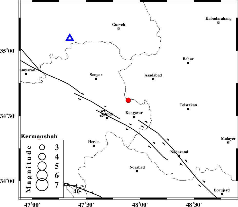
| Location | Lat:34.62 Lon: 47.89 |
| Region | Kermanshah Province, 15 km North of Kangavar |
Nearest Cities |
|
| 7 km North of Fash, Kermanshah Province | |
| 12 km West of Musaabad, Hamedan Province | |
| 14 km East of Farsinaj, Kermanshah Province | |
| 15 km North of Kangavar, Kermanshah Province | |
| 15 km South of Ajin, Hamedan Province | |
| Depth | 14 km |
| Agency | |
Faults within 150 km: |
|
| DINEHVAR_F (Length: 46 km) , Distance to epicenter: 17 km | |
| NAHAVAND_F (Length: 102 km) , Distance to epicenter: 19 km | |
| SAHANEH_F (Length: 77 km) , Distance to epicenter: 21 km | |
| Number of Phases | 7 |
| RMS | 0.3 |
| Number of Stations | 5 |
| Error in Latitude | >8.2 km |
| Error in Longitude | 6.7 km |
| Error in Depth | 8.5 km |
Download waveform in seisan format
to download seisan software Click here
to access information about IIEES stations Click here
Amplitude | ||||||||
| UID | Agency | Station | Component | Amplitude | Period | Arrival Time | Proccessing Time | Signal Clip |
| 68610 | IIEES | SNGE | E | 1332.7 | 0.16 | 2010-08-13 22:48:59 | 2010-08-13 11:01:00 | n |
| 68611 | IIEES | SNGE | N | 1928.6 | 0.24 | 2010-08-13 22:48:59 | 2010-08-13 11:01:00 | n |
| 68612 | IIEES | ASAO | N | 86 | 0.52 | 2010-08-13 22:49:38 | 2010-08-13 11:01:00 | n |
| 68613 | IIEES | ASAO | E | 81 | 0.6 | 2010-08-13 22:49:39 | 2010-08-13 11:01:00 | n |
| 68614 | IIEES | KHMZ | N | 73.2 | 0.32 | 2010-08-13 22:49:42 | 2010-08-13 11:01:00 | n |
| 68615 | IIEES | KHMZ | E | 60 | 0.36 | 2010-08-13 22:49:45 | 2010-08-13 11:01:00 | n |
Phase | ||||||||||||
| Agency | Station | Component | Phase Type | Phase Quality | First Motion | Observed Arrival Time | Time Residual | Loc. Flag | Input Weight | Distance | Azimuth | |
| IIEES | SNGE | Z | Pg | E | 2010-08-13 22:48:49 | -0.3 | y | 71.8 | 317 | |||
| IIEES | ASAO | Z | Pn | E | 2010-08-13 22:49:09 | -0.2 | y | 196 | 92 | |||
| IIEES | ASAO | E | Sg | E | 2010-08-13 22:49:32 | -0.2 | y | 196 | 92 | |||
| IIEES | KHMZ | Z | Pn | E | 2010-08-13 22:49:11 | 0.1 | y | 215 | 116 | |||
| IIEES | KHMZ | N | Sg | E | 2010-08-13 22:49:38 | -0.1 | y | 215 | 116 | |||
| IIEES | ZNJK | Z | Pn | E | 2010-08-13 22:49:14 | 0.2 | y | 239 | 17 | |||
| IIEES | GHVR | Z | Pn | E | 2010-08-13 22:49:23 | 0.6 | y | 309 | 92 | |||