
Magnitude |
:3.1 |
| Date & Time (UTC) | 2010-08-04 23:34:56.5 |
| Date & Time (Local) | 1389/5/14 04:04:56.5 |
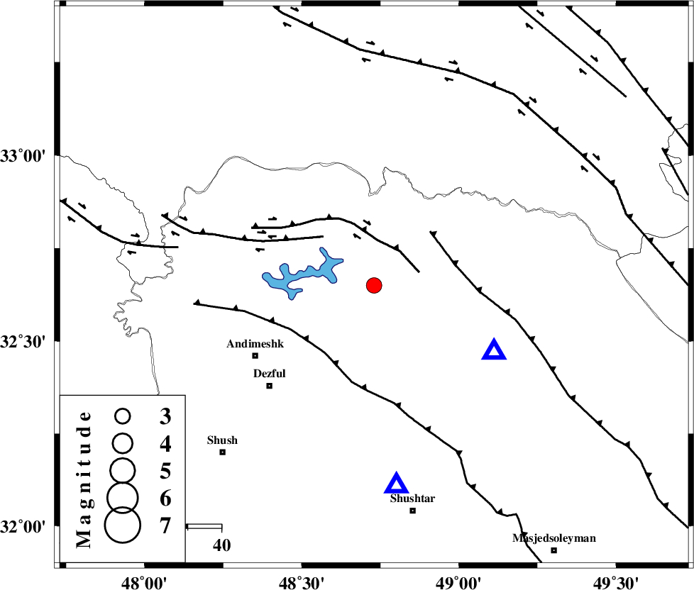
| Location | Lat:32.65 Lon: 48.73 |
| Region | Khoozestan Province, 41 km North-East of Andimeshk |
Nearest Cities |
|
| 18 km South of Shuy, Khoozestan Province | |
| 19 km North West of Sardasht, Khoozestan Province | |
| 29 km North of Mahur berenji, Khoozestan Province | |
| 40 km South East of Sorkhakan, Khoozestan Province | |
| 41 km North East of Andimeshk, Khoozestan Province | |
| Depth | 14 km |
| Agency | |
Faults within 150 km: |
|
| BALARUD_F_Z2 (Length: 58 km) , Distance to epicenter: 13 km | |
| BALARUD_F_Z3 (Length: 53 km) , Distance to epicenter: 21 km | |
| MFF2 (Length: 205 km) , Distance to epicenter: 23 km | |
| Number of Phases | 7 |
| RMS | 0.1 |
| Number of Stations | 4 |
| Error in Latitude | >1.2 km |
| Error in Longitude | 4 km |
| Error in Depth | 4.9 km |
Download waveform in seisan format
to download seisan software Click here
to access information about IIEES stations Click here
Amplitude | ||||||||
| UID | Agency | Station | Component | Amplitude | Period | Arrival Time | Proccessing Time | Signal Clip |
| 67730 | IIEES | SHGR | N | 1457.3 | 0.44 | 2010-08-04 23:35:20 | 2010-08-04 11:51:00 | n |
| 67731 | IIEES | SHGR | E | 908.1 | 0.52 | 2010-08-04 23:35:33 | 2010-08-04 11:51:00 | n |
Phase | ||||||||||||
| Agency | Station | Component | Phase Type | Phase Quality | First Motion | Observed Arrival Time | Time Residual | Loc. Flag | Input Weight | Distance | Azimuth | |
| IIEES | SHGR | Z | Pg | E | 2010-08-04 23:35:07 | 0.1 | y | 60.1 | 174 | |||
| IIEES | SHGR | N | Sg | E | 2010-08-04 23:35:14 | 0 | y | 60.1 | 174 | |||
| IIEES | KHMZ | Z | Pg | E | 2010-08-04 23:35:24 | -0.1 | y | 167 | 43 | |||
| IIEES | KHMZ | E | Sg | E | 2010-08-04 23:35:44 | 0 | y | 167 | 43 | |||
| IIEES | ASAO | Z | P | E | 2010-08-04 23:35:34 | 0.1 | y | 243 | 29 | |||
| IIEES | ASAO | E | Sg | E | 2010-08-04 23:36:05 | 0 | y | 243 | 29 | |||
| IIEES | SNGE | Z | P | E | 2010-08-04 23:35:41 | -0.1 | y | 300 | 335 | |||