
Magnitude |
:2.8 |
| Date & Time (UTC) | 2010-07-28 11:17:06.2 |
| Date & Time (Local) | 1389/5/6 15:47:06.2 |
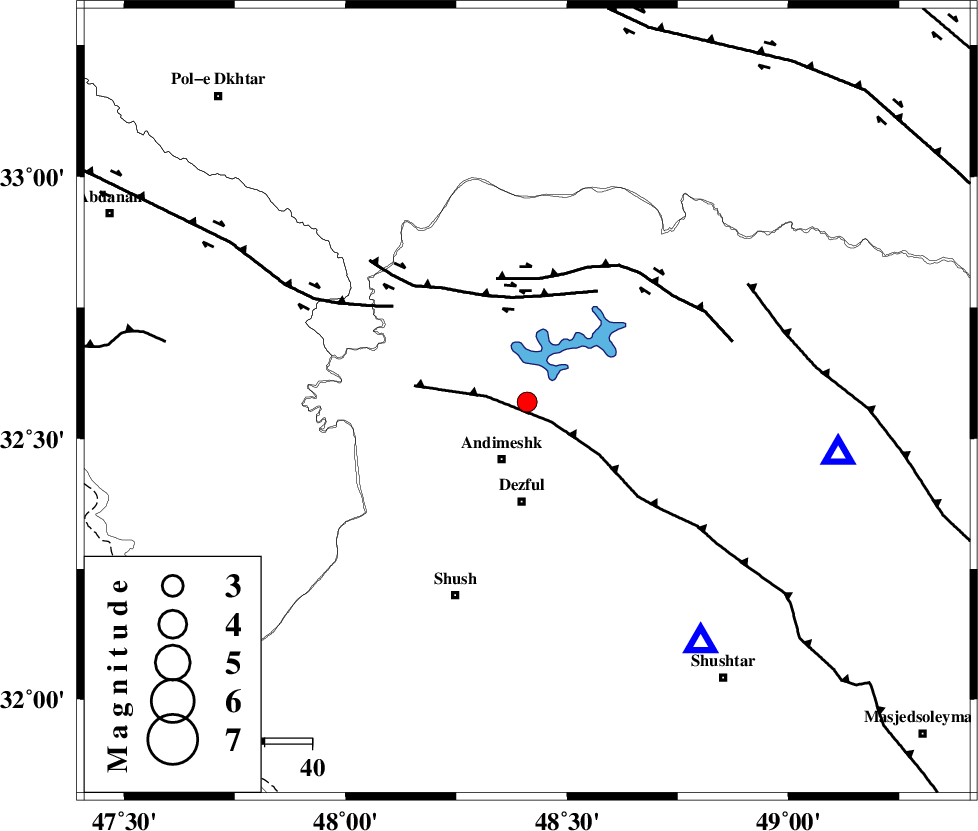
| Location | Lat:32.57 Lon: 48.41 |
| Region | Khoozestan Province, 13 km North of Andimeshk |
Nearest Cities |
|
| 13 km North of Andimeshk, Khoozestan Province | |
| 19 km South East of Hoseinieh, Khoozestan Province | |
| 21 km North of Dezful, Khoozestan Province | |
| 24 km South of Sorkhakan, Khoozestan Province | |
| 26 km South East of Bidruyeh, Khoozestan Province | |
| Depth | 18 km |
| Agency | |
Faults within 150 km: |
|
| DEZFUL_EMBAYMENT (Length: 228 km) , Distance to epicenter: 7 km | |
| BALARUD_F_Z3 (Length: 53 km) , Distance to epicenter: 22 km | |
| BALARUD_F_Z2 (Length: 58 km) , Distance to epicenter: 26 km | |
| Number of Phases | 5 |
| RMS | 0 |
| Number of Stations | 4 |
| Error in Latitude | >2 km |
| Error in Longitude | 3.9 km |
| Error in Depth | 4.9 km |
Download waveform in seisan format
to download seisan software Click here
to access information about IIEES stations Click here
Amplitude | ||||||||
| UID | Agency | Station | Component | Amplitude | Period | Arrival Time | Proccessing Time | Signal Clip |
| 66850 | IIEES | KHMZ | E | 90.5 | 0.48 | 2010-07-28 11:18:05 | 2010-07-28 11:32:00 | n |
| 66851 | IIEES | KHMZ | N | 85 | 0.36 | 2010-07-28 11:18:06 | 2010-07-28 11:32:00 | n |
| 66852 | IIEES | ASAO | E | 51.6 | 0.64 | 2010-07-28 11:18:26 | 2010-07-28 11:32:00 | n |
| 66853 | IIEES | ASAO | N | 37.8 | 0.52 | 2010-07-28 11:18:29 | 2010-07-28 11:32:00 | n |
| 66854 | IIEES | SNGE | N | 28.7 | 0.4 | 2010-07-28 11:18:29 | 2010-07-28 11:32:00 | n |
| 66855 | IIEES | SNGE | E | 53.9 | 0.68 | 2010-07-28 11:18:33 | 2010-07-28 11:32:00 | n |
Phase | ||||||||||||
| Agency | Station | Component | Phase Type | Phase Quality | First Motion | Observed Arrival Time | Time Residual | Loc. Flag | Input Weight | Distance | Azimuth | |
| IIEES | SHGR | Z | Pg | E | 2010-07-28 11:17:17 | 0 | y | 62.7 | 144 | |||
| IIEES | KHMZ | Z | Pn | E | 2010-07-28 11:17:37 | -0.1 | y | 195 | 48 | |||
| IIEES | KHMZ | N | Sg | E | 2010-07-28 11:18:01 | 0 | y | 195 | 48 | |||
| IIEES | ASAO | Z | Pn | E | 2010-07-28 11:17:46 | 0 | y | 266 | 34 | |||
| IIEES | SNGE | Z | Pn | E | 2010-07-28 11:17:50 | 0 | y | 297 | 341 | |||