
Magnitude |
:2.8 |
| Date & Time (UTC) | 2010-07-11 02:23:50.4 |
| Date & Time (Local) | 1389/4/20 06:53:50.4 |
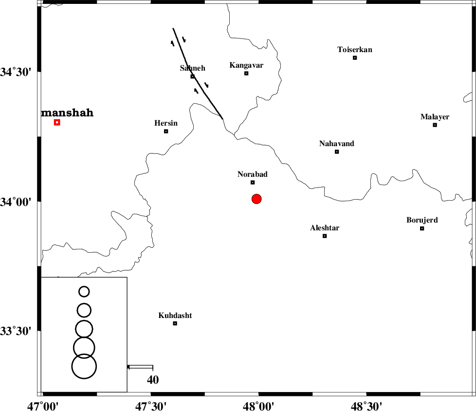
| Location | Lat:34.01 Lon: 47.99 |
| Region | Lorestan Province, 7 km Nurabad |
Nearest Cities |
|
| 4 km North of Farhadabad, Lorestan Province | |
| 7 km of Nurabad, Lorestan Province | |
| 9 km of Zafarabad, Lorestan Province | |
| 11 km of Kafraj, Lorestan Province | |
| 13 km South of Froozvand-e vosta, Lorestan Province | |
| Depth | 15 km |
| Agency | |
Faults within 150 km: |
|
| SAHANEH_F (Length: 77 km) , Distance to epicenter: 28 km | |
| HZF4 (Length: 492 km) , Distance to epicenter: 33 km | |
| NAHAVAND_F (Length: 102 km) , Distance to epicenter: 39 km | |
| Number of Phases | 4 |
| RMS | 0 |
| Number of Stations | 3 |
| Error in Latitude | >7.6 km |
| Error in Longitude | 6 km |
| Error in Depth | 6.3 km |
Download waveform in seisan format
to download seisan software Click here
to access information about IIEES stations Click here
Amplitude | ||||||||
| UID | Agency | Station | Component | Amplitude | Period | Arrival Time | Proccessing Time | Signal Clip |
| 65897 | IIEES | KHMZ | N | 100.3 | 1.03 | 2010-07-11 02:24:49 | 2010-07-14 10:36:00 | n |
| 65898 | IIEES | KHMZ | E | 89.9 | 0.28 | 2010-07-11 02:24:52 | 2010-07-14 10:36:00 | n |
| 65899 | IIEES | GHVR | E | 38.3 | 1.05 | 2010-07-11 02:25:18 | 2010-07-14 10:36:00 | n |
| 65900 | IIEES | GHVR | N | 32.6 | 1.47 | 2010-07-11 02:25:22 | 2010-07-14 10:36:00 | n |
Phase | ||||||||||||
| Agency | Station | Component | Phase Type | Phase Quality | First Motion | Observed Arrival Time | Time Residual | Loc. Flag | Input Weight | Distance | Azimuth | |
| IIEES | KHMZ | Z | Pg | E | 2010-07-11 02:24:20 | 0 | y | 185 | 99 | |||
| IIEES | KHMZ | N | Sg | E | 2010-07-11 02:24:43 | 0 | y | 185 | 99 | |||
| IIEES | ZNJK | Z | Pn | E | 2010-07-11 02:24:35 | 0 | y | 302 | 12 | |||
| IIEES | GHVR | Z | Pn | E | 2010-07-11 02:24:35 | 0 | y | 304 | 79 | |||