
Magnitude |
:3 |
| Date & Time (UTC) | 2010-05-21 04:57:21.1 |
| Date & Time (Local) | 1389/2/31 09:27:21.1 |
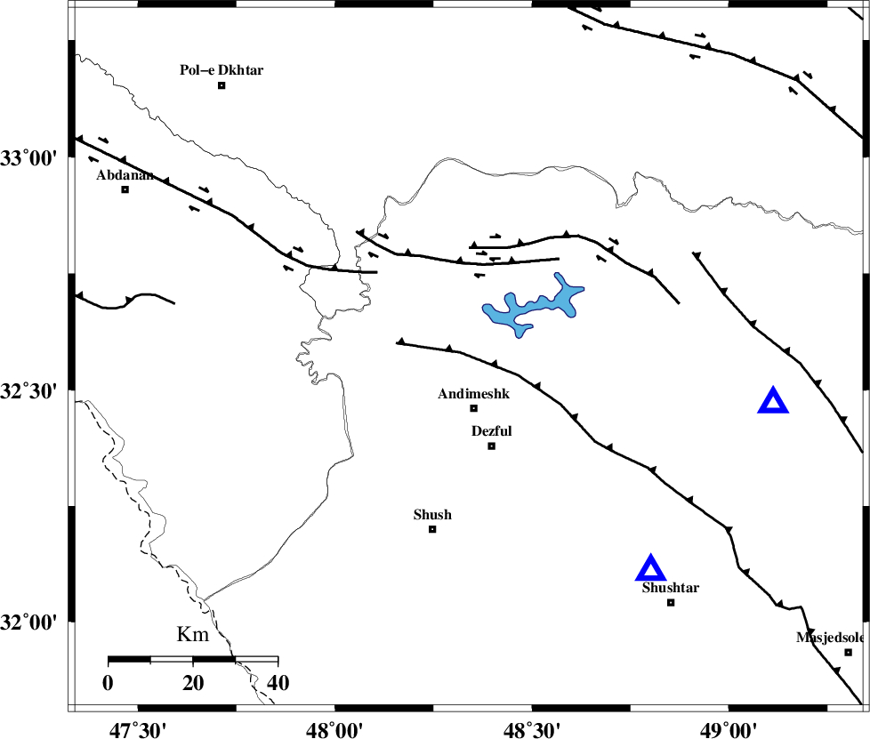
| Location | Lat:32.57 Lon: 48.34 |
| Region | Khoozestan Province, 12 km North of Andimeshk |
Nearest Cities |
|
| 12 km North of Andimeshk, Khoozestan Province | |
| 15 km South of Hoseinieh, Khoozestan Province | |
| 22 km North of Dezful, Khoozestan Province | |
| 23 km South of Sorkhakan, Khoozestan Province | |
| 23 km South East of Bidruyeh, Khoozestan Province | |
| Depth | 18 km |
| Agency | |
Faults within 150 km: |
|
| DEZFUL_EMBAYMENT (Length: 228 km) , Distance to epicenter: 2 km | |
| BALARUD_F_Z3 (Length: 53 km) , Distance to epicenter: 22 km | |
| BALARUD_F_Z2 (Length: 58 km) , Distance to epicenter: 26 km | |
| Number of Phases | 4 |
| RMS | 0.1 |
| Number of Stations | 3 |
| Error in Latitude | >1.9 km |
| Error in Longitude | 6 km |
| Error in Depth | 6.8 km |
Download waveform in seisan format
to download seisan software Click here
to access information about IIEES stations Click here
Amplitude | ||||||||
| UID | Agency | Station | Component | Amplitude | Period | Arrival Time | Proccessing Time | Signal Clip |
| 62690 | IIEES | SHGR | N | 505.3 | 0 | 2010-05-21 04:57:48 | 2010-05-21 05:13:00 | n |
| 62691 | IIEES | ASAO | N | 107 | 0.81 | 2010-05-21 04:58:43 | 2010-05-21 05:13:00 | n |
| 62692 | IIEES | ASAO | E | 72.7 | 0.73 | 2010-05-21 04:58:46 | 2010-05-21 05:13:00 | n |
| 62693 | IIEES | SNGE | E | 57.2 | 0.79 | 2010-05-21 04:58:52 | 2010-05-21 05:13:00 | n |
| 62694 | IIEES | SNGE | N | 45.8 | 0 | 2010-05-21 04:58:53 | 2010-05-21 05:13:00 | n |
Phase | ||||||||||||
| Agency | Station | Component | Phase Type | Phase Quality | First Motion | Observed Arrival Time | Time Residual | Loc. Flag | Input Weight | Distance | Azimuth | |
| IIEES | SHGR | Z | Pg | E | 2010-05-21 04:57:32 | 0 | y | 66.8 | 139 | |||
| IIEES | ASAO | Z | Pn | E | 2010-05-21 04:58:02 | -0.1 | y | 270 | 35 | |||
| IIEES | ASAO | E | Sg | E | 2010-05-21 04:58:37 | 0 | y | 270 | 35 | |||
| IIEES | SNGE | Z | Pn | E | 2010-05-21 04:58:05 | 0 | y | 295 | 342 | |||