
Magnitude |
:3.1 |
| Date & Time (UTC) | 2009-09-23 02:55:03.4 |
| Date & Time (Local) | 1388/7/1 06:25:03.4 |
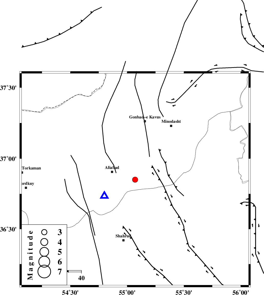
| Location | Lat:36.85 Lon: 55.07 |
| Region | Golestan Province, 19 km South of Ramian |
Nearest Cities |
|
| 19 km East of Ali Abad, Golestan Province | |
| 19 km South of Ramian, Golestan Province | |
| 20 km South of Khanbebin, Golestan Province | |
| 21 km South of Deland, Golestan Province | |
| 24 km North of Qaleh-ye nokharqan, Semnan Province | |
| Depth | 14 km |
| Agency | |
Faults within 150 km: |
|
| SHAVAR_F (Length: 87 km) , Distance to epicenter: 13 km | |
| KHAZAR_F (Length: 523 km) , Distance to epicenter: 20 km | |
| ROBATE_QARABIL_F (Length: 168 km) , Distance to epicenter: 33 km | |
| Number of Phases | 6 |
| RMS | 0.2 |
| Number of Stations | 5 |
| Error in Latitude | >6.3 km |
| Error in Longitude | 4.2 km |
| Error in Depth | 7.8 km |
Download waveform in seisan format
to download seisan software Click here
to access information about IIEES stations Click here
Amplitude | ||||||||
| UID | Agency | Station | Component | Amplitude | Period | Arrival Time | Proccessing Time | Signal Clip |
| 58612 | IIEES | MRVT | N | 576.8 | 0.24 | 2009-09-23 02:55:46 | 2009-10-25 09:10:00 | n |
| 58613 | IIEES | MRVT | E | 607.2 | 0.2 | 2009-09-23 02:55:47 | 2009-10-25 09:10:00 | n |
| 58614 | IIEES | BJRD | E | 101.2 | 0.4 | 2009-09-23 02:56:16 | 2009-10-25 09:10:00 | n |
| 58615 | IIEES | BJRD | N | 66.7 | 0.76 | 2009-09-23 02:56:26 | 2009-10-25 09:10:00 | n |
| 58616 | IIEES | DAMV | E | 84.9 | 0.44 | 2009-09-23 02:56:32 | 2009-10-25 09:10:00 | n |
| 58617 | IIEES | DAMV | N | 92.9 | 0.48 | 2009-09-23 02:56:35 | 2009-10-25 09:10:00 | n |
Phase | ||||||||||||
| Agency | Station | Component | Phase Type | Phase Quality | First Motion | Observed Arrival Time | Time Residual | Loc. Flag | Input Weight | Distance | Azimuth | |
| IIEES | MRVT | Z | Pg | E | 2009-09-23 02:55:24 | -0.3 | y | 127 | 45 | |||
| IIEES | BJRD | Z | Pg | E | 2009-09-23 02:55:40 | 0.3 | y | 227 | 65 | |||
| IIEES | DAMV | Z | Pn | E | 2009-09-23 02:55:49 | 0.1 | y | 310 | 245 | |||
| IIEES | DAMV | N | Sg | E | 2009-09-23 02:56:30 | -0.1 | y | 310 | 245 | |||
| IIEES | CHTH | Z | Pn | E | 2009-09-23 02:55:57 | 0.1 | y | 369 | 255 | |||
| IIEES | TABS | Z | Pn | E | 2009-09-23 02:56:00 | -0.1 | y | 401 | 152 | |||