
Magnitude |
:2.7 |
| Date & Time (UTC) | 2010-02-19 16:51:55.8 |
| Date & Time (Local) | 1388/11/30 20:21:55.8 |
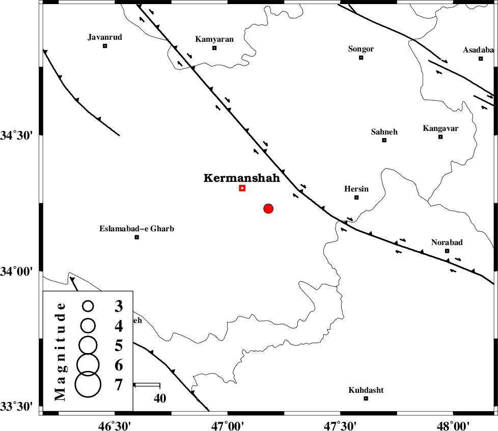
| Location | Lat:34.23 Lon: 47.18 |
| Region | 14 km East of Kermanshah, Kermanshah Province |
Nearest Cities |
|
| 1 km of Kahrar-e muqufeh, Kermanshah Province | |
| 14 km East of Kermanshah, Kermanshah Province | |
| 18 km North West of Cheshmeh kabud, Kermanshah Province | |
| 22 km North East of Helshi, Kermanshah Province | |
| 28 km North of Buzhan, Kermanshah Province | |
| Depth | 14 km |
| Agency | |
Faults within 150 km: |
|
| HZF4 (Length: 492 km) , Distance to epicenter: 22 km | |
| SAHANEH_F (Length: 77 km) , Distance to epicenter: 51 km | |
| DINEHVAR_F (Length: 46 km) , Distance to epicenter: 53 km | |
| Number of Phases | 5 |
| RMS | 0.1 |
| Number of Stations | 3 |
| Error in Latitude | >4 km |
| Error in Longitude | 4.1 km |
| Error in Depth | 7.2 km |
Download waveform in seisan format
to download seisan software Click here
to access information about IIEES stations Click here
Amplitude | ||||||||
| UID | Agency | Station | Component | Amplitude | Period | Arrival Time | Proccessing Time | Signal Clip |
| 55730 | IIEES | SNGE | N | 341.5 | 0.32 | 2010-02-19 16:52:27 | 2010-02-19 05:50:00 | n |
| 55731 | IIEES | SNGE | E | 330.9 | 0.48 | 2010-02-19 16:52:27 | 2010-02-19 05:50:00 | n |
| 55732 | IIEES | ASAO | N | 23.6 | 0.64 | 2010-02-19 16:53:20 | 2010-02-19 05:50:00 | n |
Phase | ||||||||||||
| Agency | Station | Component | Phase Type | Phase Quality | First Motion | Observed Arrival Time | Time Residual | Loc. Flag | Input Weight | Distance | Azimuth | |
| IIEES | SNGE | Z | Pg | E | 2010-02-19 16:52:12 | -0.1 | y | 97.2 | 9 | |||
| IIEES | SNGE | N | Sg | E | 2010-02-19 16:52:24 | 0.1 | y | 97.2 | 9 | |||
| IIEES | KHMZ | Z | Pn | E | 2010-02-19 16:52:36 | 0 | y | 263 | 101 | |||
| IIEES | ASAO | Z | Pn | E | 2010-02-19 16:52:36 | 0.1 | y | 264 | 81 | |||
| IIEES | ASAO | E | Sg | E | 2010-02-19 16:53:10 | 0 | y | 264 | 81 | |||