
Magnitude |
:3.3 |
| Date & Time (UTC) | 2010-02-19 10:12:20.2 |
| Date & Time (Local) | 1388/11/30 13:42:20.2 |
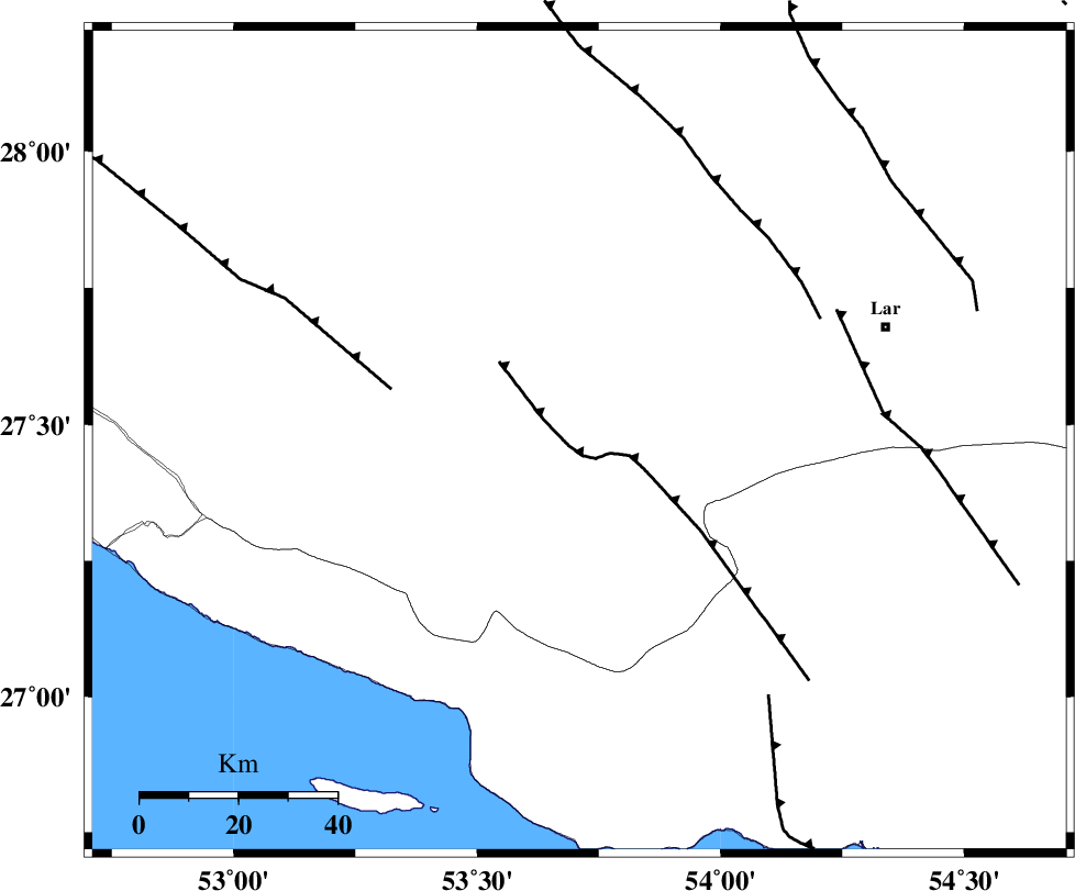
| Location | Lat:27.47 Lon: 53.71 |
| Region | 55 km North-East of Lamerd, Fars Province |
Nearest Cities |
|
| 20 km North East of Beyram, Fars Province | |
| 23 km South East of Fedagh, Fars Province | |
| 29 km North of Ashkenan, Fars Province | |
| 30 km South of Ard, Fars Province | |
| 32 km West of Bagh, Fars Province | |
| Depth | 44 km |
| Agency | |
Faults within 150 km: |
|
| LAR_F (Length: 99 km) , Distance to epicenter: 27 km | |
| MFF3 (Length: 292 km) , Distance to epicenter: 46 km | |
| BERIZ_F (Length: 49 km) , Distance to epicenter: 54 km | |
| Number of Phases | 6 |
| RMS | 0.1 |
| Number of Stations | 4 |
| Error in Latitude | >6.9 km |
| Error in Longitude | 3.9 km |
| Error in Depth | 3 km |
Download waveform in seisan format
to download seisan software Click here
to access information about IIEES stations Click here
Amplitude | ||||||||
| UID | Agency | Station | Component | Amplitude | Period | Arrival Time | Proccessing Time | Signal Clip |
| 55694 | IIEES | GHIR | E | 321 | 0.56 | 2010-02-19 10:12:58 | 2010-02-19 11:02:00 | n |
| 55695 | IIEES | GHIR | N | 355.9 | 0.48 | 2010-02-19 10:13:02 | 2010-02-19 11:02:00 | n |
| 55696 | IIEES | BNDS | E | 280.6 | 0.44 | 2010-02-19 10:13:34 | 2010-02-19 11:02:00 | n |
| 55697 | IIEES | BNDS | N | 332.4 | 0.4 | 2010-02-19 10:13:34 | 2010-02-19 11:02:00 | n |
| 55698 | IIEES | KRBR | N | 91 | 0.48 | 2010-02-19 10:14:05 | 2010-02-19 11:02:00 | n |
| 55699 | IIEES | KRBR | E | 75.3 | 0.4 | 2010-02-19 10:14:05 | 2010-02-19 11:02:00 | n |
Phase | ||||||||||||
| Agency | Station | Component | Phase Type | Phase Quality | First Motion | Observed Arrival Time | Time Residual | Loc. Flag | Input Weight | Distance | Azimuth | |
| IIEES | GHIR | Z | Pg | E | 2010-02-19 10:12:39 | -0.1 | y | 115 | 322 | |||
| IIEES | GHIR | N | Sg | E | 2010-02-19 10:12:54 | 0 | y | 115 | 322 | |||
| IIEES | BNDS | Z | P | E | 2010-02-19 10:12:55 | 0 | y | 244 | 91 | |||
| IIEES | BNDS | N | Sg | E | 2010-02-19 10:13:28 | 0 | y | 244 | 91 | |||
| IIEES | KRBR | Z | Pn | E | 2010-02-19 10:13:15 | -0.2 | y | 408 | 46 | |||
| IIEES | NASN | Z | Pn | E | 2010-02-19 10:13:39 | 0.2 | y | 597 | 352 | |||