
Magnitude |
:2.7 |
| Date & Time (UTC) | 2010-02-02 16:45:04.5 |
| Date & Time (Local) | 1388/11/13 20:15:04.5 |
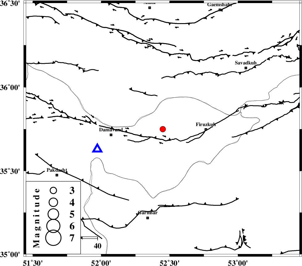
| Location | Lat:35.75 Lon: 52.45 |
| Region | 28 km West of Firuzkuh, Tehran Province |
Nearest Cities |
|
| 9 km of Arjomand, Tehran Province | |
| 17 km North East of Sarbandan, Tehran Province | |
| 22 km West of Shahrabad, Tehran Province | |
| 24 km North West of Atashan, Tehran Province | |
| 28 km North West of Firuzkuh, Tehran Province | |
| Depth | 14 km |
| Agency | |
Faults within 150 km: |
|
| MOSHA_F (Length: 234 km) , Distance to epicenter: 6 km | |
| ATARI_F (Length: 185 km) , Distance to epicenter: 46 km | |
| N_ALBORZ_F (Length: 360 km) , Distance to epicenter: 51 km | |
| Number of Phases | 5 |
| RMS | 0.1 |
| Number of Stations | 4 |
| Error in Latitude | >2.7 km |
| Error in Longitude | 4.4 km |
| Error in Depth | 4.4 km |
Download waveform in seisan format
to download seisan software Click here
to access information about IIEES stations Click here
Amplitude | ||||||||
| UID | Agency | Station | Component | Amplitude | Period | Arrival Time | Proccessing Time | Signal Clip |
| 54870 | IIEES | GHVR | N | 67.9 | 0.48 | 2010-02-02 16:46:05 | 2010-02-02 05:00:00 | n |
| 54871 | IIEES | GHVR | E | 102.2 | 0.44 | 2010-02-02 16:46:07 | 2010-02-02 05:00:00 | n |
Phase | ||||||||||||
| Agency | Station | Component | Phase Type | Phase Quality | First Motion | Observed Arrival Time | Time Residual | Loc. Flag | Input Weight | Distance | Azimuth | |
| IIEES | DAMV | Z | Pg | E | 2010-02-02 16:45:12 | 0 | y | 45 | 253 | |||
| IIEES | CHTH | Z | Pg | E | 2010-02-02 16:45:24 | 0 | y | 121 | 279 | |||
| IIEES | GHVR | Z | Pg | E | 2010-02-02 16:45:33 | -0.1 | y | 178 | 218 | |||
| IIEES | ASAO | Z | Pn | E | 2010-02-02 16:45:44 | 0.1 | y | 258 | 240 | |||
| IIEES | ASAO | E | Sg | E | 2010-02-02 16:46:17 | 0 | y | 258 | 240 | |||