
Magnitude |
:2.6 |
| Date & Time (UTC) | 2010-01-30 05:42:20.6 |
| Date & Time (Local) | 1388/11/10 09:12:20.6 |
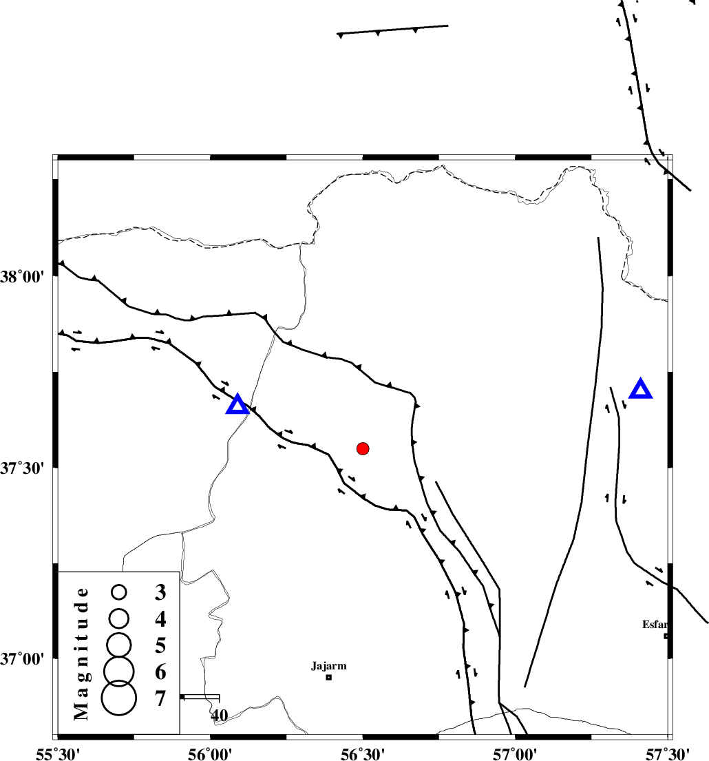
| Location | Lat:37.55 Lon: 56.5 |
| Region | 39 km West of Ashkhaneh, Khorasan(north) Province |
Nearest Cities |
|
| 26 km South East of Garmab, Khorasan(north) Province | |
| 38 km North West of Shogan, Khorasan(north) Province | |
| 39 km North West of Ashkhaneh, Khorasan(north) Province | |
| 46 km South East of Qazanqayeh, Golestan Province | |
| 46 km South West of Pish qaleh, Khorasan(north) Province | |
| Depth | 15 km |
| Agency | |
Faults within 150 km: |
|
| ROBATE_QARABIL_F (Length: 168 km) , Distance to epicenter: 25 km | |
| ESFARAYEN_F (Length: 111 km) , Distance to epicenter: 47 km | |
| JAJARAM_F (Length: 77 km) , Distance to epicenter: 58 km | |
| Number of Phases | 6 |
| RMS | 0.2 |
| Number of Stations | 4 |
| Error in Latitude | >1.8 km |
| Error in Longitude | 2.2 km |
| Error in Depth | 5.9 km |
Download waveform in seisan format
to download seisan software Click here
to access information about IIEES stations Click here
Amplitude | ||||||||
| UID | Agency | Station | Component | Amplitude | Period | Arrival Time | Proccessing Time | Signal Clip |
| 54590 | IIEES | MRVT | E | 1390.4 | 0.13 | 2010-01-30 05:42:33 | 2010-01-30 05:57:00 | n |
| 54591 | IIEES | BJRD | N | 117.2 | 0.24 | 2010-01-30 05:42:50 | 2010-01-30 05:57:00 | n |
Phase | ||||||||||||
| Agency | Station | Component | Phase Type | Phase Quality | First Motion | Observed Arrival Time | Time Residual | Loc. Flag | Input Weight | Distance | Azimuth | |
| IIEES | MRVT | Z | Pg | E | 2010-01-30 05:42:28 | 0.3 | y | 38 | 289 | |||
| IIEES | MRVT | N | Sg | E | 2010-01-30 05:42:32 | -0.2 | y | 38 | 289 | |||
| IIEES | BJRD | Z | Pg | E | 2010-01-30 05:42:34 | -0.1 | y | 82.1 | 78 | |||
| IIEES | SHRD | Z | Pg | E | 2010-01-30 05:42:49 | 0.1 | y | 176 | 194 | |||
| IIEES | SHRD | Z | Sg | E | 2010-01-30 05:43:11 | -0.1 | y | 176 | 194 | |||
| IIEES | DAMV | Z | Pn | E | 2010-01-30 05:43:25 | 0 | y | 458 | 244 | |||