
Magnitude |
:2.5 |
| Date & Time (UTC) | 2010-01-09 09:45:57.3 |
| Date & Time (Local) | 1388/10/19 13:15:57.3 |
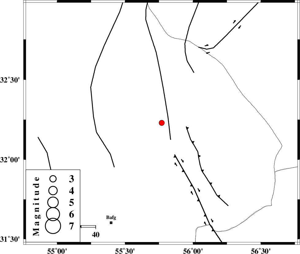
| Location | Lat:32.23 Lon: 55.77 |
| Region | 77 km North-East of Bafq, Yazd Province |
Nearest Cities |
|
| 47 km North West of Behabad, Yazd Province | |
| 55 km North of Kushk, Yazd Province | |
| 63 km North West of Benestan, Yazd Province | |
| 74 km North East of Mobarake, Yazd Province | |
| 76 km North West of Asfih, Yazd Province | |
| Depth | 15 km |
| Agency | |
Faults within 150 km: |
|
| SARBALA_F (Length: 92 km) , Distance to epicenter: 6 km | |
| JAFARABAD_F (Length: 60 km) , Distance to epicenter: 17 km | |
| KUHBANAN_F (Length: 189 km) , Distance to epicenter: 24 km | |
| Number of Phases | 3 |
| RMS | 0 |
| Number of Stations | 3 |
| Error in Latitude | >1.5 km |
| Error in Longitude | 2.2 km |
| Error in Depth | 0 km |
Download waveform in seisan format
to download seisan software Click here
to access information about IIEES stations Click here
Amplitude | ||||||||
| UID | Agency | Station | Component | Amplitude | Period | Arrival Time | Proccessing Time | Signal Clip |
| 53710 | IIEES | KRBR | N | 27 | 0.54 | 2010-01-09 09:47:20 | 2010-01-09 10:01:00 | n |
| 53711 | IIEES | KRBR | E | 27.7 | 0.25 | 2010-01-09 09:47:24 | 2010-01-09 10:01:00 | n |
| 53712 | IIEES | NASN | N | 18.9 | 0.23 | 2010-01-09 09:47:15 | 2010-01-09 10:01:00 | n |
| 53713 | IIEES | NASN | E | 13.2 | 0.28 | 2010-01-09 09:47:17 | 2010-01-09 10:01:00 | n |
Phase | ||||||||||||
| Agency | Station | Component | Phase Type | Phase Quality | First Motion | Observed Arrival Time | Time Residual | Loc. Flag | Input Weight | Distance | Azimuth | |
| IIEES | TABS | Z | Pg | E | 2010-01-09 09:46:30 | 0 | y | 202 | 38 | |||
| IIEES | KRBR | Z | Pg | E | 2010-01-09 09:46:40 | 0 | y | 266 | 159 | |||
| IIEES | NASN | Z | Pn | E | 2010-01-09 09:46:40 | 0 | y | 285 | 284 | |||