
Magnitude |
:2.5 |
| Date & Time (UTC) | 2010-01-04 00:44:00.4 |
| Date & Time (Local) | 1388/10/14 04:14:00.4 |
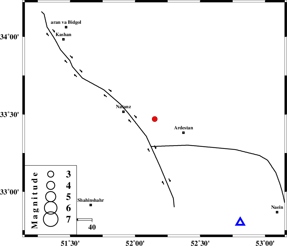
| Location | Lat:33.47 Lon: 52.15 |
| Region | 22 km East of Natanz, Esfahan Province |
Nearest Cities |
|
| 12 km of Mughar, Esfahan Province | |
| 22 km North of Kachu sang, Esfahan Province | |
| 23 km North West of Ardestan, Esfahan Province | |
| 23 km East of Natanz, Esfahan Province | |
| 25 km North East of Tameh, Esfahan Province | |
| Depth | 14 km |
| Agency | |
Faults within 150 km: |
|
| ZEFREH_F (Length: 124 km) , Distance to epicenter: 14 km | |
| CHAH_ZANGUL_F (Length: 123 km) , Distance to epicenter: 20 km | |
| KASHAN_F (Length: 44 km) , Distance to epicenter: 69 km | |
| Number of Phases | 5 |
| RMS | 0.1 |
| Number of Stations | 4 |
| Error in Latitude | >3.4 km |
| Error in Longitude | 4.7 km |
| Error in Depth | 7.1 km |
Download waveform in seisan format
to download seisan software Click here
to access information about IIEES stations Click here
Amplitude | ||||||||
| UID | Agency | Station | Component | Amplitude | Period | Arrival Time | Proccessing Time | Signal Clip |
| 53490 | IIEES | NASN | E | 176.2 | 0.16 | 2010-01-04 00:44:29 | 2010-01-04 12:53:00 | n |
| 53491 | IIEES | NASN | N | 121.8 | 0.12 | 2010-01-04 00:44:29 | 2010-01-04 12:53:00 | n |
| 53492 | IIEES | GHVR | N | 70.6 | 0.2 | 2010-01-04 00:44:46 | 2010-01-04 12:53:00 | n |
| 53493 | IIEES | DAMV | N | 29.2 | 0.16 | 2010-01-04 00:45:10 | 2010-01-04 12:53:00 | n |
| 53494 | IIEES | DAMV | E | 37.6 | 0.6 | 2010-01-04 00:45:12 | 2010-01-04 12:53:00 | n |
Phase | ||||||||||||
| Agency | Station | Component | Phase Type | Phase Quality | First Motion | Observed Arrival Time | Time Residual | Loc. Flag | Input Weight | Distance | Azimuth | |
| IIEES | NASN | Z | P | E | 2010-01-04 00:44:16 | -0.1 | y | 96.3 | 140 | |||
| IIEES | NASN | N | Sg | E | 2010-01-04 00:44:29 | 0.07 | y | 96.3 | 140 | |||
| IIEES | GHVR | Z | P | E | 2010-01-04 00:44:23 | -0.05 | y | 140 | 324 | |||
| IIEES | ASAO | Z | P | E | 2010-01-04 00:44:36 | 0.06 | y | 230 | 302 | |||
| IIEES | DAMV | Z | P | E | 2010-01-04 00:44:38 | 0.03 | y | 241 | 356 | |||