
Magnitude |
:3.6 |
| Date & Time (UTC) | 2009-01-28 06:42:20.3 |
| Date & Time (Local) | 1387/11/9 10:12:20.3 |
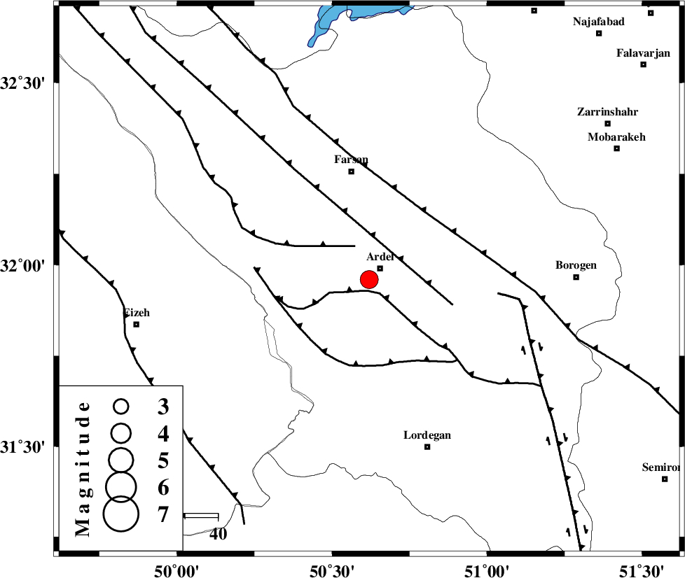
| Location | Lat:31.96 Lon: 50.62 |
| Region | 4 km Ardel, Chaharmahal Bakhtiari Province |
Nearest Cities |
|
| 5 km North of Dupelan, Chaharmahal Bakhtiari Province | |
| 5 km of Ardel, Chaharmahal Bakhtiari Province | |
| 11 km North West of Naghan, Chaharmahal Bakhtiari Province | |
| 16 km South of Rostamabad, Chaharmahal Bakhtiari Province | |
| 20 km West of Shalamzar, Chaharmahal Bakhtiari Province | |
| Depth | 14 km |
| Agency | |
Faults within 150 km: |
|
| DOPOLAN_F (Length: 107 km) , Distance to epicenter: 4 km | |
| ZARDKUH_F (Length: 139 km) , Distance to epicenter: 11 km | |
| SABZKUH_F (Length: 67 km) , Distance to epicenter: 26 km | |
| Number of Phases | 6 |
| RMS | 0.4 |
| Number of Stations | 6 |
| Error in Latitude | >11.8 km |
| Error in Longitude | 6 km |
| Error in Depth | 11 km |
Download waveform in seisan format
to download seisan software Click here
to access information about IIEES stations Click here
Amplitude | ||||||||
| UID | Agency | Station | Component | Amplitude | Period | Arrival Time | Proccessing Time | Signal Clip |
| 51763 | IIEES | DAMV | E | 74.3 | 0.48 | 2009-01-28 06:44:32 | 2009-06-27 08:52:00 | n |
| 51764 | IIEES | DAMV | N | 88.7 | 0.54 | 2009-01-28 06:44:33 | 2009-06-27 08:52:00 | n |
| 51765 | IIEES | SNGE | E | 68.5 | 0.64 | 2009-01-28 06:44:47 | 2009-06-27 08:52:00 | n |
| 51766 | IIEES | SNGE | N | 95.3 | 0.69 | 2009-01-28 06:44:48 | 2009-06-27 08:52:00 | n |
Phase | ||||||||||||
| Agency | Station | Component | Phase Type | Phase Quality | First Motion | Observed Arrival Time | Time Residual | Loc. Flag | Input Weight | Distance | Azimuth | |
| IIEES | SHGR | Z | Pg | E | 2009-01-28 06:42:48 | 0.1 | y | 172 | 276 | |||
| IIEES | KHMZ | Z | Pg | E | 2009-01-28 06:42:54 | -0.2 | y | 206 | 343 | |||
| IIEES | NASN | Z | Pg | E | 2009-01-28 06:42:57 | -0.2 | y | 226 | 65 | |||
| IIEES | DAMV | Z | Pn | E | 2009-01-28 06:43:21 | 0.7 | y | 426 | 17 | |||
| IIEES | SNGE | Z | Pn | E | 2009-01-28 06:43:24 | -0.5 | y | 461 | 320 | |||
| IIEES | ZNJK | Z | Pn | E | 2009-01-28 06:43:36 | 0.1 | y | 552 | 342 | |||