
Magnitude |
:2.6 |
| Date & Time (UTC) | 2009-01-13 16:59:20.0 |
| Date & Time (Local) | 1387/10/24 20:29:20.0 |
| Location | Lat:32.6 Lon: 49.94 |
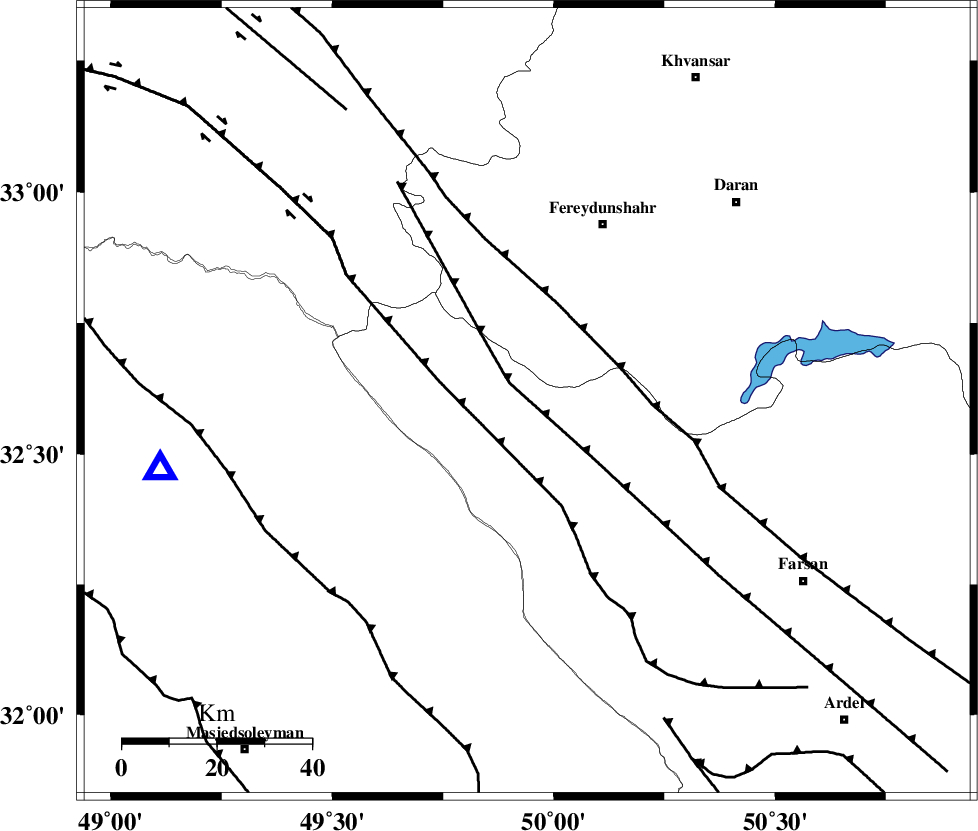
| Region | 22 km North-West of Chelgard, Chaharmahal Bakhtiari Province |
Nearest Cities |
|
| 13 km of Durak, Chaharmahal Bakhtiari Province | |
| 23 km North West of Chelgard, Chaharmahal Bakhtiari Province | |
| 29 km South of Masir, Esfahan Province | |
| 31 km South West of Ghale? sorkh, Esfahan Province | |
| 33 km North West of Kukanak, Esfahan Province | |
| Depth | 15 km |
| Agency | |
Faults within 150 km: |
|
| ARDAL_F (Length: 170 km) , Distance to epicenter: 5 km | |
| ZARDKUH_F (Length: 139 km) , Distance to epicenter: 19 km | |
| MAIN_ZAGROS_R_F (Length: 1106 km) , Distance to epicenter: 21 km | |
| Number of Phases | 3 |
| RMS | 0 |
| Number of Stations | 3 |
| Error in Latitude | >2 km |
| Error in Longitude | 2.1 km |
| Error in Depth | 0 km |
Download waveform in seisan format
to download seisan software Click here
to access information about IIEES stations Click here
Amplitude | ||||||||
| UID | Agency | Station | Component | Amplitude | Period | Arrival Time | Proccessing Time | Signal Clip |
| 51698 | IIEES | SHGR | N | 140.4 | 0.35 | 2009-01-13 17:00:00 | 2009-06-27 08:52:00 | n |
| 51699 | IIEES | SHGR | E | 110.7 | 0.3 | 2009-01-13 17:00:02 | 2009-06-27 08:52:00 | n |
| 51700 | IIEES | ASAO | N | 50.8 | 0.52 | 2009-01-13 17:00:27 | 2009-06-27 08:52:00 | n |
Phase | ||||||||||||
| Agency | Station | Component | Phase Type | Phase Quality | First Motion | Observed Arrival Time | Time Residual | Loc. Flag | Input Weight | Distance | Azimuth | |
| IIEES | SHGR | Z | Pg | E | 2009-01-13 16:59:40 | 0 | y | 120 | 243 | |||
| IIEES | ASAO | Z | Pg | E | 2009-01-13 16:59:55 | 0 | y | 216 | 2 | |||
| IIEES | NASN | Z | Pn | E | 2009-01-13 17:00:01 | 0 | y | 270 | 85 | |||