
Magnitude |
:3.1 |
| Date & Time (UTC) | 2008-11-30 02:55:19.0 |
| Date & Time (Local) | 1387/9/10 06:25:19.0 |
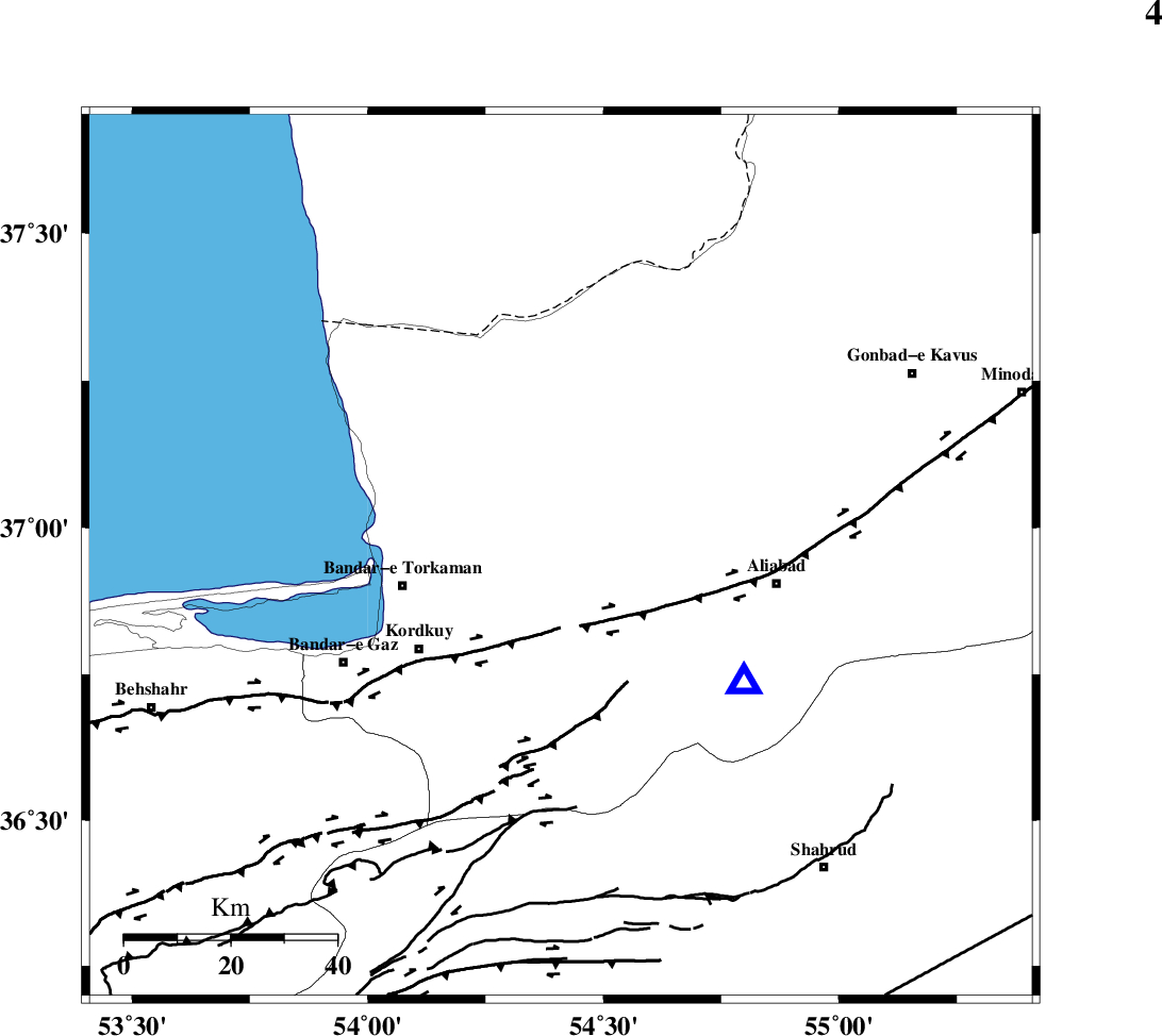
| Location | Lat:36.95 Lon: 54.41 |
| Region | 8 km Aq Qaleh, Golestan Province |
Nearest Cities |
|
| 8 km of Aq Qaleh, Golestan Province | |
| 11 km of Qanqarmeh, Golestan Province | |
| 13 km North of Gorgan, Golestan Province | |
| 14 km North of Lamsak, Golestan Province | |
| 16 km West of Nodeh malek, Golestan Province | |
| Depth | 14 km |
| Agency | |
Faults within 150 km: |
|
| KHAZAR_F (Length: 523 km) , Distance to epicenter: 14 km | |
| N_ALBORZ_F (Length: 360 km) , Distance to epicenter: 38 km | |
| SHAVAR_F (Length: 87 km) , Distance to epicenter: 42 km | |
| Number of Phases | 4 |
| RMS | 0.1 |
| Number of Stations | 4 |
| Error in Latitude | >6 km |
| Error in Longitude | 4.7 km |
| Error in Depth | 5 km |
Download waveform in seisan format
to download seisan software Click here
to access information about IIEES stations Click here
Amplitude | ||||||||
| UID | Agency | Station | Component | Amplitude | Period | Arrival Time | Proccessing Time | Signal Clip |
| 51312 | IIEES | DAMV | E | 108.9 | 0.9 | 2008-11-30 02:56:34 | 2009-05-17 10:07:00 | n |
| 51313 | IIEES | DAMV | N | 105.1 | 0.97 | 2008-11-30 02:56:36 | 2009-05-17 10:07:00 | n |
| 51314 | IIEES | NASN | E | 14.5 | 0.14 | 2008-11-30 02:57:29 | 2009-05-17 10:07:00 | n |
Phase | ||||||||||||
| Agency | Station | Component | Phase Type | Phase Quality | First Motion | Observed Arrival Time | Time Residual | Loc. Flag | Input Weight | Distance | Azimuth | |
| IIEES | MRVT | Z | Pg | E | 2008-11-30 02:55:46 | -0.1 | y | 169 | 61 | |||
| IIEES | DAMV | E | Sg | E | 2008-11-30 02:56:33 | -0.1 | y | 263 | 237 | |||
| IIEES | CHTH | Z | Pn | E | 2008-11-30 02:56:06 | 0.1 | y | 316 | 250 | |||
| IIEES | NASN | Z | Pn | E | 2008-11-30 02:56:27 | 0.1 | y | 483 | 198 | |||