
Magnitude |
:3.1 |
| Date & Time (UTC) | 2008-03-24 01:25:05.6 |
| Date & Time (Local) | 1387/1/5 05:55:05.6 |
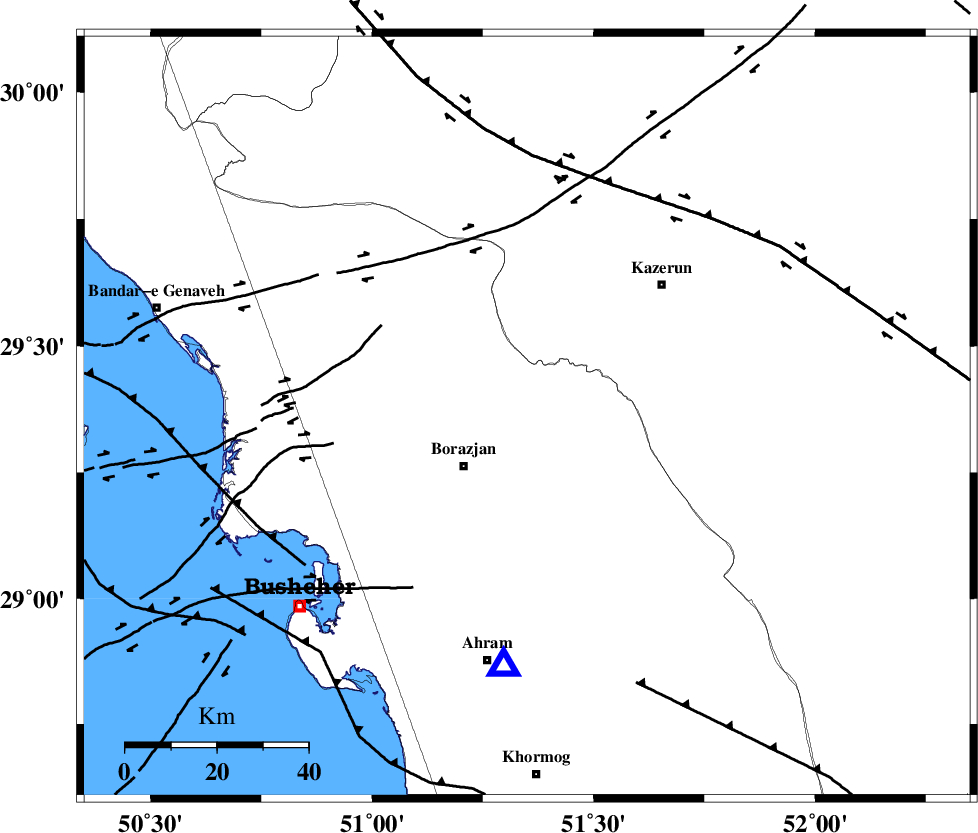
| Location | Lat:29.36 Lon: 51.35 |
| Region | 17 km East of Borazjan, Bushehr Province |
Nearest Cities |
|
| 10 km of Dalki, Bushehr Province | |
| 16 km East of Nazar aqa, Bushehr Province | |
| 18 km North East of Borazjan, Bushehr Province | |
| 22 km East of Saedabad, Bushehr Province | |
| 23 km South of Khesht, Fars Province | |
| Depth | 15 km |
| Agency | |
Faults within 150 km: |
|
| BORAZJAN_F (Length: 168 km) , Distance to epicenter: 12 km | |
| ZFF3 (Length: 125 km) , Distance to epicenter: 13 km | |
| KAZERUN_F (Length: 96 km) , Distance to epicenter: 30 km | |
| Number of Phases | 6 |
| RMS | 0.2 |
| Number of Stations | 6 |
| Error in Latitude | >4.1 km |
| Error in Longitude | 6.2 km |
| Error in Depth | 0 km |
Download waveform in seisan format
to download seisan software Click here
to access information about IIEES stations Click here
Amplitude | ||||||||
| UID | Agency | Station | Component | Amplitude | Period | Arrival Time | Proccessing Time | Signal Clip |
| 48710 | IIEES | GHIR | N | 190.3 | 0.68 | 2008-03-24 01:26:14 | 2008-12-28 01:25:00 | n |
| 48711 | IIEES | GHIR | E | 164 | 0.48 | 2008-03-24 01:26:16 | 2008-12-28 01:25:00 | n |
| 48712 | IIEES | KRBR | E | 13.2 | 0.64 | 2008-03-24 01:27:43 | 2008-12-28 01:25:00 | n |
Phase | ||||||||||||
| Agency | Station | Component | Phase Type | Phase Quality | First Motion | Observed Arrival Time | Time Residual | Loc. Flag | Input Weight | Distance | Azimuth | |
| IIEES | GHIR | Z | Pg | E | 2008-03-24 01:25:38 | 0 | y | 199 | 126 | |||
| IIEES | NASN | Z | Pn | E | 2008-03-24 01:26:04 | 0.1 | y | 406 | 20 | |||
| IIEES | KRBR | Z | Pn | E | 2008-03-24 01:26:19 | 0 | y | 529 | 81 | |||
| IIEES | ASAO | Z | Pn | E | 2008-03-24 01:26:26 | 0.1 | y | 589 | 348 | |||
| IIEES | DAMV | Z | Pn | E | 2008-03-24 01:26:39 | -0.4 | y | 698 | 5 | |||
| IIEES | SNGE | Z | Pn | E | 2008-03-24 01:26:45 | 0.1 | y | 739 | 330 | |||