
Magnitude |
:4 |
| Date & Time (UTC) | 2008-03-19 08:15:26.1 |
| Date & Time (Local) | 1386/12/29 11:45:26.1 |
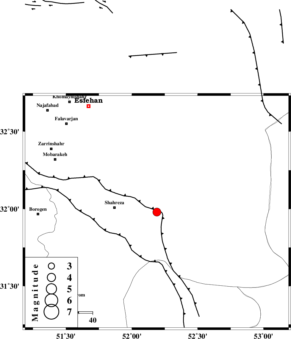
| Location | Lat:31.98 Lon: 52.19 |
| Region | 30 km East of Shahreza, Esfahan Province |
Nearest Cities |
|
| 30 km East of Shahreza, Esfahan Province | |
| 33 km North West of Ramsheh, Esfahan Province | |
| 36 km South of Nikabad, Esfahan Province | |
| 38 km South of Mohammadabad, Esfahan Province | |
| 43 km North East of Musaabad, Esfahan Province | |
| Depth | 14 km |
| Agency | |
Faults within 150 km: |
|
| MAIN_ZAGROS_R_F (Length: 1106 km) , Distance to epicenter: 70 km | |
| DENA_F (Length: 137 km) , Distance to epicenter: 102 km | |
| DOPOLAN_F (Length: 107 km) , Distance to epicenter: 102 km | |
| Number of Phases | 9 |
| RMS | 0.3 |
| Number of Stations | 8 |
| Error in Latitude | >4.3 km |
| Error in Longitude | 9.1 km |
| Error in Depth | 12.6 km |
Download waveform in seisan format
to download seisan software Click here
to access information about IIEES stations Click here
Amplitude | ||||||||
| UID | Agency | Station | Component | Amplitude | Period | Arrival Time | Proccessing Time | Signal Clip |
| 48628 | IIEES | SHGR | E | 362 | 0.57 | 2008-03-19 08:17:02 | 2008-12-28 01:25:00 | n |
| 48629 | IIEES | ASAO | N | 266.9 | 0.6 | 2008-03-19 08:17:04 | 2008-12-28 01:25:00 | n |
| 48630 | IIEES | ASAO | E | 259.1 | 0.6 | 2008-03-19 08:17:14 | 2008-12-28 01:25:00 | n |
| 48631 | IIEES | DAMV | N | 396.7 | 0.57 | 2008-03-19 08:17:20 | 2008-12-28 01:25:00 | n |
| 48632 | IIEES | DAMV | E | 421.5 | 0.52 | 2008-03-19 08:17:29 | 2008-12-28 01:25:00 | n |
Phase | ||||||||||||
| Agency | Station | Component | Phase Type | Phase Quality | First Motion | Observed Arrival Time | Time Residual | Loc. Flag | Input Weight | Distance | Azimuth | |
| IIEES | NASN | Z | Pg | E | 2008-03-19 08:15:44 | -0.2 | y | 108 | 32 | |||
| IIEES | GHVR | Z | Pn | E | 2008-03-19 08:16:10 | 0.6 | y | 291 | 343 | |||
| IIEES | SHGR | Z | Pn | E | 2008-03-19 08:16:13 | -0.1 | y | 320 | 273 | |||
| IIEES | ASAO | Z | Pn | E | 2008-03-19 08:16:17 | -0.4 | y | 349 | 325 | |||
| IIEES | DAMV | Z | Pn | E | 2008-03-19 08:16:24 | 0.4 | y | 405 | 357 | |||
| IIEES | DAMV | E | Sg | E | 2008-03-19 08:17:19 | -0.1 | y | 405 | 357 | |||
| IIEES | GHIR | Z | Pn | E | 2008-03-19 08:16:25 | 0 | y | 417 | 169 | |||
| IIEES | CHTH | Z | Pn | E | 2008-03-19 08:16:29 | -0.2 | y | 447 | 348 | |||
| IIEES | THKV | Z | Pn | E | 2008-03-19 08:16:30 | 0.1 | y | 453 | 345 | |||