
Magnitude |
:2.7 |
| Date & Time (UTC) | 2008-01-26 00:22:30.6 |
| Date & Time (Local) | 1386/11/6 03:52:30.6 |
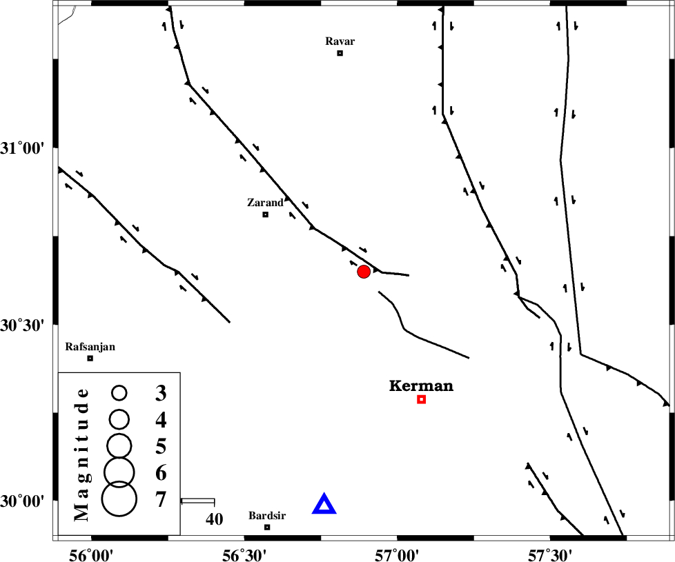
| Location | Lat:30.65 Lon: 56.89 |
| Region | 35 km South-East of Zarand, Kerman Province |
Nearest Cities |
|
| 5 km North of Chatrud, Kerman Province | |
| 9 km North of Hutak, Kerman Province | |
| 10 km North of Kazemabad, Kerman Province | |
| 13 km East of Khankuk, Kerman Province | |
| 15 km South of Hejdak, Kerman Province | |
| Depth | 6 km |
| Agency | |
Faults within 150 km: |
|
| KUHBANAN_F (Length: 189 km) , Distance to epicenter: 6 km | |
| CHATRUD_F (Length: 37 km) , Distance to epicenter: 8 km | |
| LAKARKUH_F (Length: 138 km) , Distance to epicenter: 42 km | |
| Number of Phases | 4 |
| RMS | 0 |
| Number of Stations | 3 |
| Error in Latitude | >3.7 km |
| Error in Longitude | 3.3 km |
| Error in Depth | 9 km |
Download waveform in seisan format
to download seisan software Click here
to access information about IIEES stations Click here
Amplitude | ||||||||
| UID | Agency | Station | Component | Amplitude | Period | Arrival Time | Proccessing Time | Signal Clip |
| 48023 | IIEES | KRBR | E | 376 | 0.16 | 2008-01-26 00:23:01 | 2008-12-28 01:25:00 | n |
| 48024 | IIEES | KRBR | N | 480 | 0.48 | 2008-01-26 00:23:05 | 2008-12-28 01:25:00 | n |
| 48025 | IIEES | NASN | N | 9.3 | 0.64 | 2008-01-26 00:24:53 | 2008-12-28 01:25:00 | n |
Phase | ||||||||||||
| Agency | Station | Component | Phase Type | Phase Quality | First Motion | Observed Arrival Time | Time Residual | Loc. Flag | Input Weight | Distance | Azimuth | |
| IIEES | KRBR | Z | Pg | E | 2008-01-26 00:22:43 | 0 | y | 75.2 | 190 | |||
| IIEES | KRBR | N | Sg | E | 2008-01-26 00:22:53 | 0 | y | 75.2 | 190 | |||
| IIEES | ZHSF | Z | Pn | E | 2008-01-26 00:23:28 | 0 | y | 391 | 106 | |||
| IIEES | NASN | Z | Pn | E | 2008-01-26 00:23:36 | 0 | y | 454 | 303 | |||