
Magnitude |
:2.7 |
| Date & Time (UTC) | 2007-10-25 00:45:28.6 |
| Date & Time (Local) | 1386/8/3 04:15:28.6 |
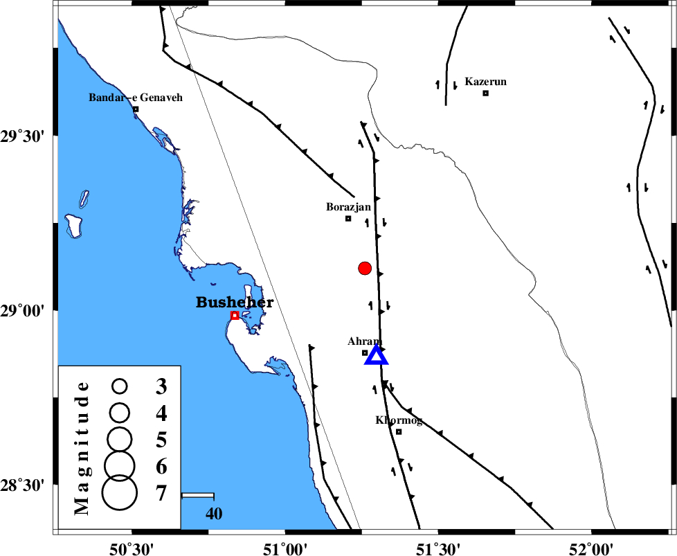
| Location | Lat:29.12 Lon: 51.26 |
| Region | 16 km South of Borazjan, Bushehr Province |
Nearest Cities |
|
| 10 km of Sarkareh, Bushehr Province | |
| 17 km South of Borazjan, Bushehr Province | |
| 20 km North of Bazuei, Bushehr Province | |
| 26 km South East of Ziyarat, Bushehr Province | |
| 26 km North East of Choghadak, Bushehr Province | |
| Depth | 18 km |
| Agency | |
Faults within 150 km: |
|
| BORAZJAN_F (Length: 168 km) , Distance to epicenter: 10 km | |
| ZFF3 (Length: 125 km) , Distance to epicenter: 23 km | |
| ZFF2 (Length: 84 km) , Distance to epicenter: 30 km | |
| Number of Phases | 6 |
| RMS | 0.1 |
| Number of Stations | 5 |
| Error in Latitude | >18.7 km |
| Error in Longitude | 8.6 km |
| Error in Depth | 31.5 km |
Download waveform in seisan format
to download seisan software Click here
to access information about IIEES stations Click here
Amplitude | ||||||||
| UID | Agency | Station | Component | Amplitude | Period | Arrival Time | Proccessing Time | Signal Clip |
| 39939 | IIEES | GHIR | N | 231.6 | 0.49 | 2007-10-25 00:46:35 | 2008-04-12 10:47:00 | n |
| 39940 | IIEES | GHIR | E | 152.6 | 0.79 | 2007-10-25 00:46:35 | 2008-04-12 10:47:00 | n |
| 39941 | IIEES | NASN | N | 3.6 | 0.22 | 2007-10-25 00:47:18 | 2008-04-12 10:47:00 | n |
| 39942 | IIEES | NASN | E | 6 | 0.65 | 2007-10-25 00:47:19 | 2008-04-12 10:47:00 | n |
Phase | ||||||||||||
| Agency | Station | Component | Phase Type | Phase Quality | First Motion | Observed Arrival Time | Time Residual | Loc. Flag | Input Weight | Distance | Azimuth | |
| IIEES | GHIR | Z | Pg | E | 2007-10-25 00:46:00 | 0 | y | 193 | 118 | |||
| IIEES | GHIR | E | Sg | E | 2007-10-25 00:46:23 | 0 | y | 193 | 118 | |||
| IIEES | NASN | Z | Pn | E | 2007-10-25 00:46:30 | -0.1 | y | 434 | 20 | |||
| IIEES | ASAO | Z | Pn | E | 2007-10-25 00:46:52 | 0.3 | y | 613 | 349 | |||
| IIEES | DAMV | Z | Pn | E | 2007-10-25 00:47:06 | -0.1 | y | 725 | 5 | |||
| IIEES | SNGE | Z | Pn | E | 2007-10-25 00:47:10 | -0.2 | y | 758 | 332 | |||