
Magnitude |
:2.5 |
| Date & Time (UTC) | 2007-08-27 19:47:24.1 |
| Date & Time (Local) | 1386/6/5 23:17:24.1 |
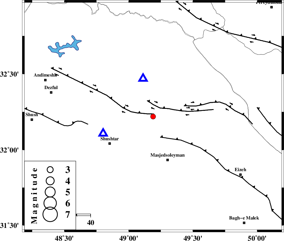
| Location | Lat:32.22 Lon: 49.19 |
| Region | 20 km South of Lali, Khoozestan Province |
Nearest Cities |
|
| 8 km of Jaefarabad, Khoozestan Province | |
| 15 km North East of Haft shahidan, Khoozestan Province | |
| 20 km South of Lali, Khoozestan Province | |
| 24 km North West of Qale-yekhvaju, Khoozestan Province | |
| 32 km North East of Samaleh, Khoozestan Province | |
| Depth | 41 km |
| Agency | |
Faults within 150 km: |
|
| DEZFUL_EMBAYMENT (Length: 228 km) , Distance to epicenter: 18 km | |
| MFF2 (Length: 205 km) , Distance to epicenter: 21 km | |
| BALARUD_F_Z2 (Length: 58 km) , Distance to epicenter: 60 km | |
| Number of Phases | 5 |
| RMS | 0 |
| Number of Stations | 3 |
| Error in Latitude | >3.6 km |
| Error in Longitude | 5.6 km |
| Error in Depth | 1.9 km |
Download waveform in seisan format
to download seisan software Click here
to access information about IIEES stations Click here
Amplitude | ||||||||
| UID | Agency | Station | Component | Amplitude | Period | Arrival Time | Proccessing Time | Signal Clip |
| 39550 | IIEES | SHGR | N | 507.2 | 0.28 | 2007-08-27 19:47:42 | 2007-11-04 01:43:00 | n |
| 39551 | IIEES | SHGR | E | 435.1 | 0.39 | 2007-08-27 19:47:44 | 2007-11-04 01:43:00 | n |
| 39552 | IIEES | ASAO | N | 16.6 | 0.53 | 2007-08-27 19:48:46 | 2007-11-04 01:43:00 | n |
| 39553 | IIEES | ASAO | E | 21.2 | 0.44 | 2007-08-27 19:48:52 | 2007-11-04 01:43:00 | n |
Phase | ||||||||||||
| Agency | Station | Component | Phase Type | Phase Quality | First Motion | Observed Arrival Time | Time Residual | Loc. Flag | Input Weight | Distance | Azimuth | |
| IIEES | SHGR | Z | Pg | E | 2007-08-27 19:47:33 | 0 | y | 39 | 251 | |||
| IIEES | SHGR | N | Sg | E | 2007-08-27 19:47:39 | 0 | y | 39 | 251 | |||
| IIEES | ASAO | Z | Pn | E | 2007-08-27 19:48:03 | 0 | y | 269 | 16 | |||
| IIEES | ASAO | N | Sg | E | 2007-08-27 19:48:38 | 0 | y | 269 | 16 | |||
| IIEES | SNGE | Z | Pn | E | 2007-08-27 19:48:14 | 0 | y | 362 | 332 | |||