
Magnitude |
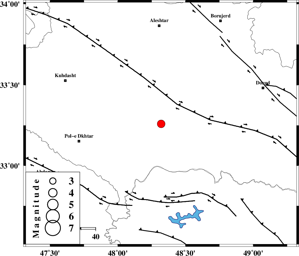
:3.6 |
| Date & Time (UTC) | 2007-08-14 17:39:55.2 |
| Date & Time (Local) | 1386/5/23 21:09:55.2 |
| Location | Lat:33.26 Lon: 48.32 |
| Region | 25 km South of Khorramabad, Lorestan Province |
Nearest Cities |
|
| 15 km South of Daraei, Lorestan Province | |
| 19 km South East of Shoorab-e sofla, Lorestan Province | |
| 22 km South of Badrabad-e sofla, Lorestan Province | |
| 25 km South West of Kamalvand-e gholamali, Lorestan Province | |
| 25 km South of Khorramabad, Lorestan Province | |
| Depth | 39 km |
| Agency | |
Faults within 150 km: |
|
| HZF4 (Length: 492 km) , Distance to epicenter: 17 km | |
| BALARUD_F_Z2 (Length: 58 km) , Distance to epicenter: 51 km | |
| BALARUD_F_Z3 (Length: 53 km) , Distance to epicenter: 53 km | |
| Number of Phases | 8 |
| RMS | 0.6 |
| Number of Stations | 6 |
| Error in Latitude | >5.8 km |
| Error in Longitude | 8.3 km |
| Error in Depth | 10.7 km |
Download waveform in seisan format
to download seisan software Click here
to access information about IIEES stations Click here
Amplitude | ||||||||
| UID | Agency | Station | Component | Amplitude | Period | Arrival Time | Proccessing Time | Signal Clip |
| 39214 | IIEES | SHGR | N | 1200.6 | 0.97 | 2007-08-14 17:40:40 | 2007-11-04 01:43:00 | n |
| 39215 | IIEES | SHGR | E | 1356.5 | 0.64 | 2007-08-14 17:40:40 | 2007-11-04 01:43:00 | n |
| 39216 | IIEES | ASAO | E | 488.9 | 0.81 | 2007-08-14 17:40:59 | 2007-11-04 01:43:00 | n |
Phase | ||||||||||||
| Agency | Station | Component | Phase Type | Phase Quality | First Motion | Observed Arrival Time | Time Residual | Loc. Flag | Input Weight | Distance | Azimuth | |
| IIEES | SHGR | Z | Pg | E | 2007-08-14 17:40:18 | 0.3 | y | 136 | 160 | |||
| IIEES | ASAO | Z | Pg | E | 2007-08-14 17:40:28 | -1 | y | 213 | 48 | |||
| IIEES | ASAO | E | Sg | E | 2007-08-14 17:40:55 | 0.8 | y | 213 | 48 | |||
| IIEES | SNGE | Z | P | E | 2007-08-14 17:40:28 | 0.6 | y | 222 | 337 | |||
| IIEES | SNGE | E | Sg | E | 2007-08-14 17:40:56 | -0.3 | y | 222 | 337 | |||
| IIEES | CHTH | Z | Pn | E | 2007-08-14 17:40:49 | 0.1 | y | 391 | 41 | |||
| IIEES | NASN | Z | Pn | E | 2007-08-14 17:40:52 | -0.6 | y | 423 | 96 | |||
| IIEES | DAMV | Z | Pn | E | 2007-08-14 17:40:53 | 0 | y | 426 | 51 | |||