
Magnitude |
:2.7 |
| Date & Time (UTC) | 2007-09-04 01:27:06.1 |
| Date & Time (Local) | 1386/6/13 04:57:06.1 |
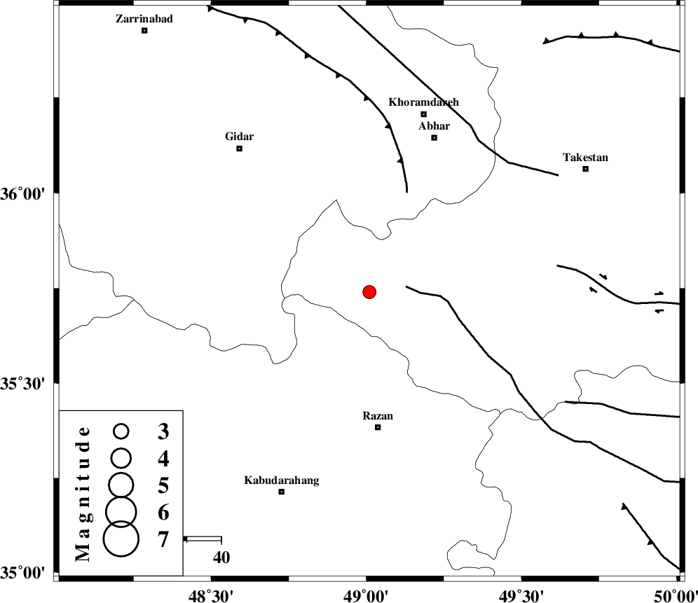
| Location | Lat:35.74 Lon: 49.01 |
| Region | 39 km North of Razan, Hamedan Province |
Nearest Cities |
|
| 25 km West of Ab-e garm, Ghazvin Province | |
| 27 km North West of Avaj, Ghazvin Province | |
| 31 km North East of Kahla, Zanjan Province | |
| 31 km North East of Khorandeh, Hamedan Province | |
| 37 km West of Hoseynabad, Ghazvin Province | |
| Depth | 14 km |
| Agency | |
Faults within 150 km: |
|
| KUSHK_E_NOSRAT_F (Length: 230 km) , Distance to epicenter: 11 km | |
| SOLTANIYEH_F (Length: 119 km) , Distance to epicenter: 31 km | |
| ZANJAN_F (Length: 137 km) , Distance to epicenter: 54 km | |
| Number of Phases | 6 |
| RMS | 0.1 |
| Number of Stations | 5 |
| Error in Latitude | >4.1 km |
| Error in Longitude | 2.3 km |
| Error in Depth | 5.2 km |
Download waveform in seisan format
to download seisan software Click here
to access information about IIEES stations Click here
Amplitude | ||||||||
| UID | Agency | Station | Component | Amplitude | Period | Arrival Time | Proccessing Time | Signal Clip |
| 38844 | IIEES | SNGE | E | 130.3 | 0.49 | 2007-09-04 01:27:55 | 2007-11-04 01:43:00 | n |
| 38845 | IIEES | SNGE | N | 151.1 | 0.46 | 2007-09-04 01:27:55 | 2007-11-04 01:43:00 | n |
| 38846 | IIEES | THKV | E | 47.9 | 0.02 | 2007-09-04 01:27:56 | 2007-11-04 01:43:00 | n |
Phase | ||||||||||||
| Agency | Station | Component | Phase Type | Phase Quality | First Motion | Observed Arrival Time | Time Residual | Loc. Flag | Input Weight | Distance | Azimuth | |
| IIEES | ASAO | Z | Pg | E | 2007-09-04 01:27:32 | 0 | y | 161 | 145 | |||
| IIEES | SNGE | Z | Pg | E | 2007-09-04 01:27:33 | 0 | y | 167 | 245 | |||
| IIEES | THKV | Z | Pg | E | 2007-09-04 01:27:34 | 0.2 | y | 170 | 83 | |||
| IIEES | THKV | N | Sg | E | 2007-09-04 01:27:54 | -0.1 | y | 170 | 83 | |||
| IIEES | CHTH | Z | Pg | E | 2007-09-04 01:27:37 | -0.2 | y | 192 | 84 | |||
| IIEES | DAMV | Z | Pn | E | 2007-09-04 01:27:47 | 0 | y | 269 | 92 | |||