
Magnitude |
:3.1 |
| Date & Time (UTC) | 2007-03-30 17:50:29.3 |
| Date & Time (Local) | 1386/1/10 21:20:29.3 |
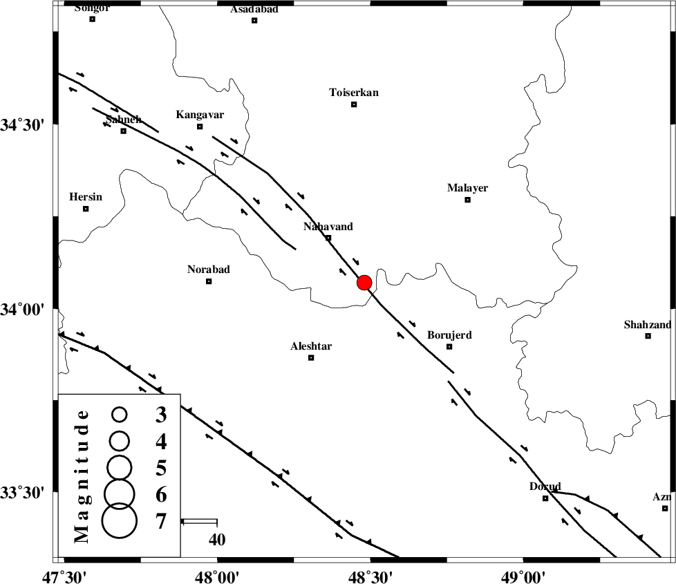
| Location | Lat:34.07 Lon: 48.48 |
| Region | 17 km South-East of Nahavand, Hamedan Province |
Nearest Cities |
|
| 1 km of Babaqasem, Hamedan Province | |
| 7 km North of Jaefarabad, Lorestan Province | |
| 10 km of Anuj, Hamedan Province | |
| 17 km North West of Ashtarinan, Lorestan Province | |
| 17 km South East of Nahavand, Hamedan Province | |
| Depth | 18 km |
| Agency | |
Faults within 150 km: |
|
| NAHAVAND_F (Length: 102 km) , Distance to epicenter: 8 km | |
| SAHANEH_F (Length: 77 km) , Distance to epicenter: 23 km | |
| DORUD (Length: 100 km) , Distance to epicenter: 39 km | |
| Number of Phases | 8 |
| RMS | 0.6 |
| Number of Stations | 6 |
| Error in Latitude | >10.1 km |
| Error in Longitude | 6.2 km |
| Error in Depth | 0 km |
Download waveform in seisan format
to download seisan software Click here
to access information about IIEES stations Click here
Amplitude | ||||||||
| UID | Agency | Station | Component | Amplitude | Period | Arrival Time | Proccessing Time | Signal Clip |
| 37712 | IIEES | ASAO | N | 396.3 | 0.64 | 2007-03-30 17:51:14 | 2007-04-22 03:28:00 | n |
| 37713 | IIEES | ASAO | E | 289.3 | 0.44 | 2007-03-30 17:51:15 | 2007-04-22 03:28:00 | n |
| 37714 | IIEES | DAMV | E | 41.4 | 0.64 | 2007-03-30 17:52:10 | 2007-04-22 03:28:00 | n |
| 37715 | IIEES | DAMV | N | 40.1 | 0.44 | 2007-03-30 17:52:17 | 2007-04-22 03:28:00 | n |
Phase | ||||||||||||
| Agency | Station | Component | Phase Type | Phase Quality | First Motion | Observed Arrival Time | Time Residual | Loc. Flag | Input Weight | Distance | Azimuth | |
| IIEES | ASAO | Z | Pg | E | 2007-03-30 17:50:54 | -0.6 | y | 152 | 69 | |||
| IIEES | ASAO | N | Sg | E | 2007-03-30 17:51:13 | -0.1 | y | 152 | 69 | |||
| IIEES | SNGE | Z | Pg | E | 2007-03-30 17:50:54 | -0.3 | y | 154 | 318 | |||
| IIEES | GHVR | Z | Pg | E | 2007-03-30 17:51:11 | 0 | y | 259 | 79 | |||
| IIEES | GHVR | N | Sg | E | 2007-03-30 17:51:42 | -0.1 | y | 259 | 79 | |||
| IIEES | CHTH | N | Sg | E | 2007-03-30 17:51:58 | -0.1 | y | 316 | 49 | |||
| IIEES | DAMV | Z | Pn | E | 2007-03-30 17:51:23 | 1.6 | y | 363 | 61 | |||
| IIEES | NASN | Z | Pn | E | 2007-03-30 17:51:29 | -0.3 | y | 427 | 108 | |||