
Magnitude |
:4.6 |
| Date & Time (UTC) | 2007-03-06 22:32:05.1 |
| Date & Time (Local) | 1385/12/16 02:02:05.1 |
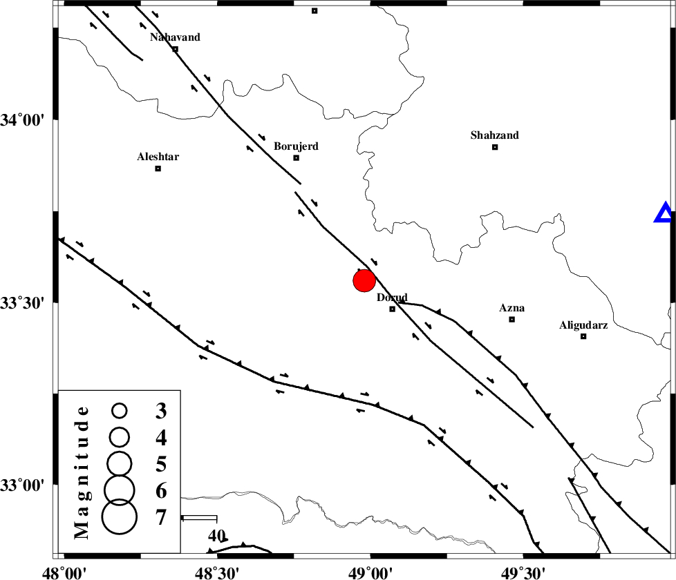
| Location | Lat:33.56 Lon: 48.98 |
| Region | 12 km Dorud, Lorestan Province |
Nearest Cities |
|
| 4 km North of Void, Lorestan Province | |
| 6 km of Kagheh, Lorestan Province | |
| 10 km East of Razan, Lorestan Province | |
| 12 km North of Dorud, Lorestan Province | |
| 14 km North West of Zhan, Lorestan Province | |
| Depth | 14 km |
| Agency | |
Faults within 150 km: |
|
| DORUD (Length: 100 km) , Distance to epicenter: 4 km | |
| MAIN_ZAGROS_R_F (Length: 1106 km) , Distance to epicenter: 12 km | |
| NAHAVAND_F (Length: 102 km) , Distance to epicenter: 35 km | |
| Number of Phases | 8 |
| RMS | 0.1 |
| Number of Stations | 8 |
| Error in Latitude | >1.4 km |
| Error in Longitude | 2.5 km |
| Error in Depth | 3.3 km |
Download waveform in seisan format
to download seisan software Click here
to access information about IIEES stations Click here
Amplitude | ||||||||
| UID | Agency | Station | Component | Amplitude | Period | Arrival Time | Proccessing Time | Signal Clip |
| 37555 | IIEES | ASAO | E | 7211 | 0.67 | 2007-03-06 22:32:54 | 2007-04-22 03:28:00 | n |
| 37556 | IIEES | ASAO | N | 8360.1 | 1.32 | 2007-03-06 22:33:00 | 2007-04-22 03:28:00 | n |
| 37557 | IIEES | SHGR | E | 11745.4 | 0.53 | 2007-03-06 22:32:58 | 2007-04-22 03:28:00 | n |
| 37558 | IIEES | SHGR | N | 12277.9 | 1.05 | 2007-03-06 22:33:04 | 2007-04-22 03:28:00 | n |
| 37559 | IIEES | DAMV | N | 846.7 | 0.27 | 2007-03-06 22:33:56 | 2007-04-22 03:28:00 | n |
Phase | ||||||||||||
| Agency | Station | Component | Phase Type | Phase Quality | First Motion | Observed Arrival Time | Time Residual | Loc. Flag | Input Weight | Distance | Azimuth | |
| IIEES | ASAO | Z | Pg | E | 2007-03-06 22:32:29 | -0.1 | y | 146 | 41 | |||
| IIEES | SHGR | Z | Pg | E | 2007-03-06 22:32:31 | 0 | y | 162 | 186 | |||
| IIEES | SNGE | Z | Pg | E | 2007-03-06 22:32:42 | 0 | y | 226 | 319 | |||
| IIEES | THKV | Z | Pn | E | 2007-03-06 22:32:51 | -0.1 | y | 314 | 33 | |||
| IIEES | CHTH | Z | Pn | E | 2007-03-06 22:32:53 | 0.1 | y | 326 | 36 | |||
| IIEES | DAMV | Z | Pn | E | 2007-03-06 22:32:57 | 0.1 | y | 358 | 49 | |||
| IIEES | NASN | Z | Pn | E | 2007-03-06 22:32:58 | 0 | y | 367 | 102 | |||
| IIEES | GRMI | Z | Pn | E | 2007-03-06 22:33:26 | 0 | y | 590 | 351 | |||