
Magnitude |
:2.7 |
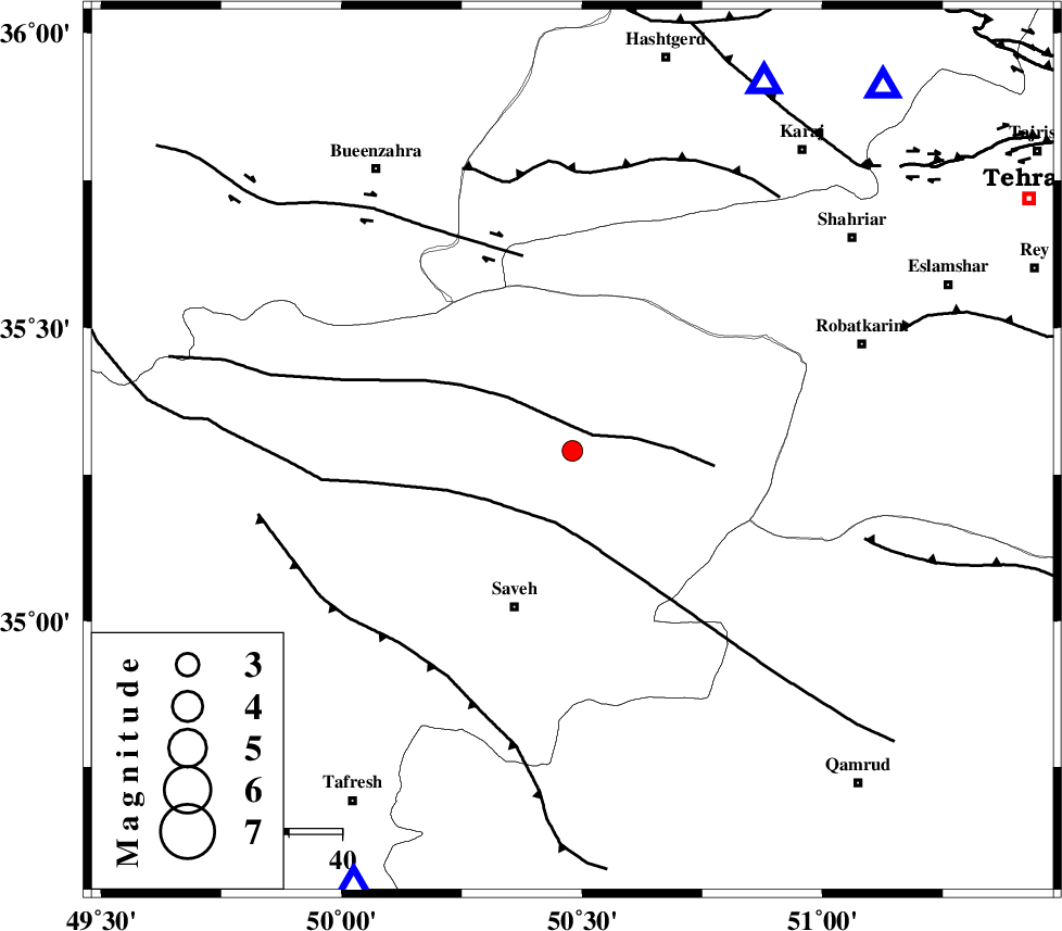
| Date & Time (UTC) | 2006-07-24 21:26:43.5 |
| Date & Time (Local) | 1385/5/3 00:56:43.5 |
| Location | Lat:35.29 Lon: 50.48 |
| Region | 31 km North-East of Saveh, Markazi Province |
Nearest Cities |
|
| 4 km of Memunieh, Markazi Province | |
| 7 km of Hakimabad, Markazi Province | |
| 12 km of Zaviyeh, Markazi Province | |
| 18 km South East of Khoshkrud, Markazi Province | |
| 20 km West of Rahimabad, Markazi Province | |
| Depth | 30 km |
| Agency | |
Faults within 150 km: |
|
| S_PARANDAK_F (Length: 116 km) , Distance to epicenter: 5 km | |
| KUSHK_E_NOSRAT_F (Length: 230 km) , Distance to epicenter: 14 km | |
| IPAK_F (Length: 80 km) , Distance to epicenter: 38 km | |
| Number of Phases | 7 |
| RMS | 0.1 |
| Number of Stations | 5 |
| Error in Latitude | >2.4 km |
| Error in Longitude | 2.8 km |
| Error in Depth | 4.9 km |
Download waveform in seisan format
to download seisan software Click here
to access information about IIEES stations Click here
Amplitude | ||||||||
| UID | Agency | Station | Component | Amplitude | Period | Arrival Time | Proccessing Time | Signal Clip |
| 36035 | IIEES | THKV | N | 313.5 | 0.24 | 2006-07-24 21:27:08 | 2006-10-17 03:59:00 | n |
| 36036 | IIEES | THKV | E | 350.7 | 0.24 | 2006-07-24 21:27:08 | 2006-10-17 03:59:00 | n |
| 36037 | IIEES | DAMV | N | 104.5 | 0.12 | 2006-07-24 21:27:25 | 2006-10-17 03:59:00 | n |
| 36038 | IIEES | DAMV | E | 136.2 | 0.16 | 2006-07-24 21:27:27 | 2006-10-17 03:59:00 | n |
Phase | ||||||||||||
| Agency | Station | Component | Phase Type | Phase Quality | First Motion | Observed Arrival Time | Time Residual | Loc. Flag | Input Weight | Distance | Azimuth | |
| IIEES | THKV | Z | PG | E | 2006-07-24 21:26:57 | 0.2 | y | 78.8 | 27 | |||
| IIEES | CHTH | Z | PG | E | 2006-07-24 21:26:59 | -0.2 | y | 90.6 | 40 | |||
| IIEES | ASAO | Z | PG | E | 2006-07-24 21:26:59 | 0.1 | y | 91.7 | 207 | |||
| IIEES | ASAO | N | SG | E | 2006-07-24 21:27:10 | 0 | y | 91.7 | 207 | |||
| IIEES | DAMV | Z | PG | E | 2006-07-24 21:27:06 | 0 | y | 141 | 74 | |||
| IIEES | DAMV | E | SG | E | 2006-07-24 21:27:23 | 0.1 | y | 141 | 74 | |||
| IIEES | SNGE | Z | PN | E | 2006-07-24 21:27:25 | 0 | y | 286 | 267 | |||