
Magnitude |
:2.8 |
| Date & Time (UTC) | 2006-08-13 18:10:19.2 |
| Date & Time (Local) | 1385/5/22 21:40:19.2 |
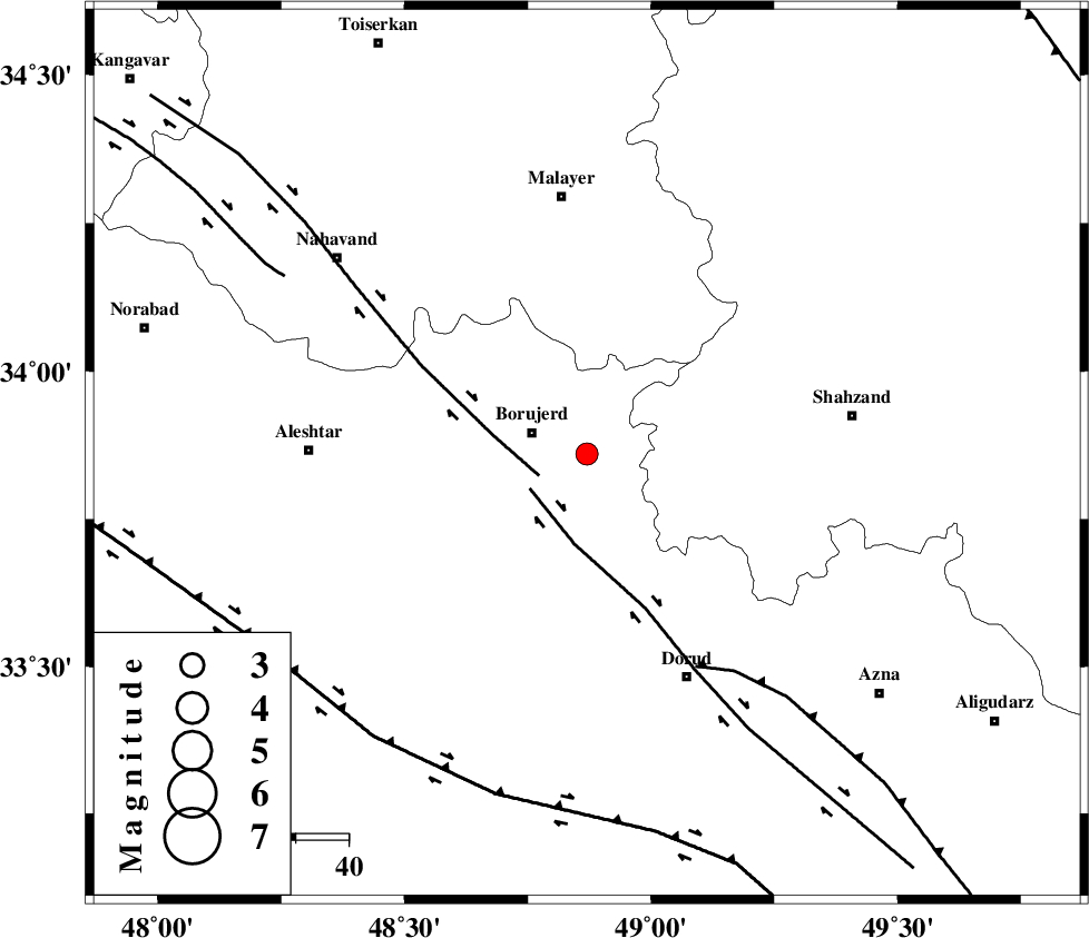
| Location | Lat:33.86 Lon: 48.87 |
| Region | 11 km East of Borujerd, Lorestan Province |
Nearest Cities |
|
| 3 km of Valanjerd, Lorestan Province | |
| 7 km North of Hemmatabad, Lorestan Province | |
| 11 km East of Borujerd, Lorestan Province | |
| 20 km North West of Hashian, Markazi Province | |
| 22 km West of Dehkaeed, Markazi Province | |
| Depth | 14 km |
| Agency | |
Faults within 150 km: |
|
| NAHAVAND_F (Length: 102 km) , Distance to epicenter: 10 km | |
| DORUD (Length: 100 km) , Distance to epicenter: 13 km | |
| MAIN_ZAGROS_R_F (Length: 1106 km) , Distance to epicenter: 45 km | |
| Number of Phases | 7 |
| RMS | 0 |
| Number of Stations | 5 |
| Error in Latitude | >0.9 km |
| Error in Longitude | 1.5 km |
| Error in Depth | 2.9 km |
Download waveform in seisan format
to download seisan software Click here
to access information about IIEES stations Click here
Amplitude | ||||||||
| UID | Agency | Station | Component | Amplitude | Period | Arrival Time | Proccessing Time | Signal Clip |
| 35616 | IIEES | ASAO | N | 184.1 | 0.37 | 2006-08-13 18:11:02 | 2006-10-17 03:59:00 | n |
| 35617 | IIEES | ASAO | E | 201.7 | 0.43 | 2006-08-13 18:11:04 | 2006-10-17 03:59:00 | n |
| 35618 | IIEES | SHGR | E | 117 | 0.6 | 2006-08-13 18:11:20 | 2006-10-17 03:59:00 | n |
| 35619 | IIEES | SHGR | N | 92.9 | 0.56 | 2006-08-13 18:11:21 | 2006-10-17 03:59:00 | n |
| 35620 | IIEES | SNGE | N | 109.4 | 0.38 | 2006-08-13 18:11:23 | 2006-10-17 03:59:00 | n |
Phase | ||||||||||||
| Agency | Station | Component | Phase Type | Phase Quality | First Motion | Observed Arrival Time | Time Residual | Loc. Flag | Input Weight | Distance | Azimuth | |
| IIEES | ASAO | Z | PG | E | 2006-08-13 18:10:41 | 0 | y | 131 | 54 | |||
| IIEES | ASAO | N | SG | E | 2006-08-13 18:10:57 | 0 | y | 131 | 54 | |||
| IIEES | SHGR | Z | PG | E | 2006-08-13 18:10:51 | -0.1 | y | 195 | 182 | |||
| IIEES | SHGR | N | SG | E | 2006-08-13 18:11:14 | 0 | y | 195 | 182 | |||
| IIEES | SNGE | Z | PG | E | 2006-08-13 18:10:51 | 0 | y | 196 | 315 | |||
| IIEES | DAMV | Z | PN | E | 2006-08-13 18:11:09 | 0 | y | 345 | 54 | |||
| IIEES | NASN | Z | PN | E | 2006-08-13 18:11:15 | 0.1 | y | 385 | 107 | |||