
Magnitude |
:3 |
| Date & Time (UTC) | 2006-06-23 09:08:53.3 |
| Date & Time (Local) | 1385/4/2 12:38:53.3 |
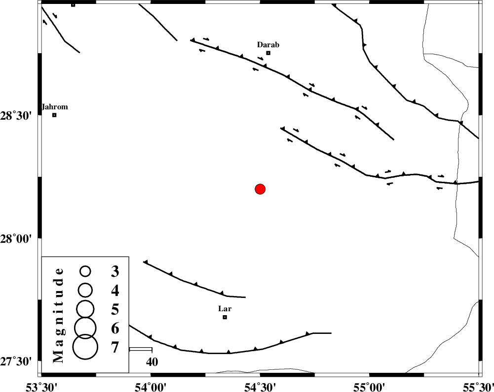
| Location | Lat:28.2 Lon: 54.5 |
| Region | 59 km North-East of Lar, Fars Province |
Nearest Cities |
|
| 19 km South of Hajiabad, Fars Province | |
| 20 km South East of Shahr-e pir, Fars Province | |
| 37 km South East of Dabiran, Fars Province | |
| 39 km North of Dehkuyeh, Fars Province | |
| 53 km South of Nasrovan, Fars Province | |
| Depth | 15 km |
| Agency | |
Faults within 150 km: |
|
| HZF2 (Length: 437 km) , Distance to epicenter: 29 km | |
| BERIZ_F (Length: 49 km) , Distance to epicenter: 49 km | |
| HZF1 (Length: 102 km) , Distance to epicenter: 50 km | |
| Number of Phases | 5 |
| RMS | 0.2 |
| Number of Stations | 3 |
| Error in Latitude | >4.8 km |
| Error in Longitude | 2.2 km |
| Error in Depth | 0 km |
Download waveform in seisan format
to download seisan software Click here
to access information about IIEES stations Click here
Amplitude | ||||||||
| UID | Agency | Station | Component | Amplitude | Period | Arrival Time | Proccessing Time | Signal Clip |
| 35055 | IIEES | GHIR | E | 326.1 | 0.52 | 2006-06-23 09:09:38 | 2008-03-02 12:02:00 | n |
| 35056 | IIEES | GHIR | N | 264.4 | 0.56 | 2006-06-23 09:09:46 | 2008-03-02 12:02:00 | n |
| 35057 | IIEES | BNDS | E | 111.1 | 0.56 | 2006-06-23 09:10:03 | 2008-03-02 12:02:00 | n |
Phase | ||||||||||||
| Agency | Station | Component | Phase Type | Phase Quality | First Motion | Observed Arrival Time | Time Residual | Loc. Flag | Input Weight | Distance | Azimuth | |
| IIEES | GHIR | Z | PG | E | 2006-06-23 09:09:18 | -0.2 | y | 149 | 274 | |||
| IIEES | GHIR | N | SG | E | 2006-06-23 09:09:36 | 0.1 | y | 149 | 274 | |||
| IIEES | BNDS | Z | Pg | E | 2006-06-23 09:09:23 | -0.3 | y | 187 | 118 | |||
| IIEES | BNDS | E | SG | E | 2006-06-23 09:09:46 | 0.2 | y | 187 | 118 | |||
| IIEES | NASN | Z | PN | E | 2006-06-23 09:10:07 | 0.1 | y | 536 | 343 | |||