
Magnitude |
:3.7 |
| Date & Time (UTC) | 2004-12-22 15:55:10.6 |
| Date & Time (Local) | 1383/10/2 19:25:10.6 |
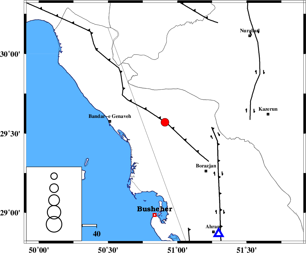
| Location | Lat:29.57 Lon: 50.91 |
| Region | 38 km East of Bandar-e genaveh, Bushehr Province |
Nearest Cities |
|
| 13 km North East of Chehar rustaee, Bushehr Province | |
| 13 km North of Dehkohneh, Bushehr Province | |
| 29 km North East of Bandarehrig, Bushehr Province | |
| 30 km North West of Saedabad, Bushehr Province | |
| 30 km East of Mohammad salehi, Bushehr Province | |
| Depth | 14 km |
| Agency | |
Faults within 150 km: |
|
| ZFF3 (Length: 125 km) , Distance to epicenter: 2 km | |
| BORAZJAN_F (Length: 168 km) , Distance to epicenter: 33 km | |
| KAZERUN_F (Length: 96 km) , Distance to epicenter: 59 km | |
| Number of Phases | 7 |
| RMS | 0.3 |
| Number of Stations | 6 |
| Error in Latitude | >8.3 km |
| Error in Longitude | 8.6 km |
| Error in Depth | 13.7 km |
Download waveform in seisan format
to download seisan software Click here
to access information about IIEES stations Click here
Amplitude | ||||||||
| UID | Agency | Station | Component | Amplitude | Period | Arrival Time | Proccessing Time | Signal Clip |
| 31419 | IIEES | SHGR | E | 248.3 | 0.6 | 2004-12-22 15:57:00 | 2006-03-15 11:56:00 | n |
| 31420 | IIEES | SHGR | N | 206.5 | 0.6 | 2004-12-22 15:57:19 | 2006-03-15 11:56:00 | n |
| 31421 | IIEES | ASAO | N | 51.5 | 0.68 | 2004-12-22 15:57:27 | 2006-03-15 11:56:00 | n |
| 31422 | IIEES | ASAO | E | 44.7 | 0.64 | 2004-12-22 15:57:27 | 2006-03-15 11:56:00 | n |
Phase | ||||||||||||
| Agency | Station | Component | Phase Type | Phase Quality | First Motion | Observed Arrival Time | Time Residual | Loc. Flag | Input Weight | Distance | Azimuth | |
| IIEES | GHIR | Z | PG | E | 2004-12-22 15:55:51 | 0 | y | 247 | 125 | |||
| IIEES | GHIR | N | SG | E | 2004-12-22 15:56:20 | -0.1 | y | 247 | 125 | |||
| IIEES | SHGR | Z | PN | E | 2004-12-22 15:56:01 | -0.1 | y | 346 | 325 | |||
| IIEES | NASN | Z | PN | E | 2004-12-22 15:56:08 | 0.1 | y | 401 | 26 | |||
| IIEES | ASAO | Z | PN | E | 2004-12-22 15:56:28 | 0.3 | y | 559 | 352 | |||
| IIEES | BNDS | Z | PN | E | 2004-12-22 15:56:29 | 0.4 | y | 568 | 114 | |||
| IIEES | DAMV | Z | PN | E | 2004-12-22 15:56:42 | -0.5 | y | 680 | 8 | |||