
Magnitude |
:2.8 |
| Date & Time (UTC) | 2004-12-12 01:38:06.6 |
| Date & Time (Local) | 1383/9/22 05:08:06.6 |
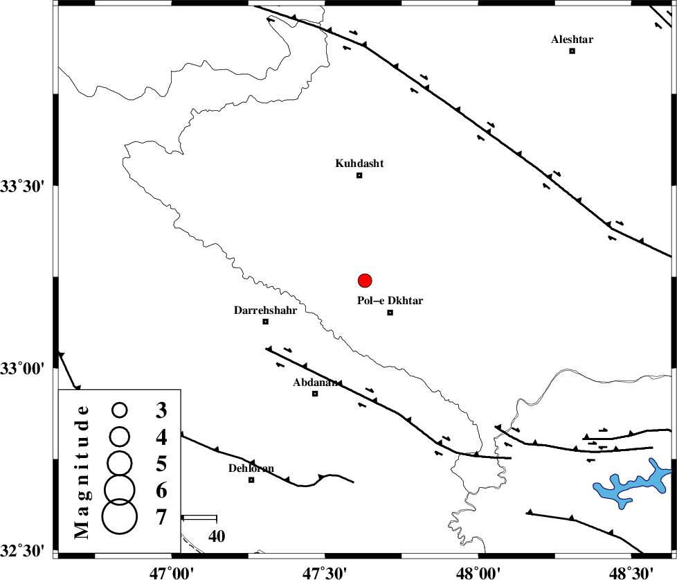
| Location | Lat:33.24 Lon: 47.63 |
| Region | 11 km Pol-e dokhtar, Lorestan Province |
Nearest Cities |
|
| 9 km of Morani, Lorestan Province | |
| 12 km North of Pol-e dokhtar, Lorestan Province | |
| 15 km East of Chaqabol, Lorestan Province | |
| 17 km North of Sarab hammam, Lorestan Province | |
| 20 km East of Suri, Lorestan Province | |
| Depth | 46 km |
| Agency | |
Faults within 150 km: |
|
| BALARUD_F_Z1 (Length: 87 km) , Distance to epicenter: 37 km | |
| HZF4 (Length: 492 km) , Distance to epicenter: 59 km | |
| BALARUD_F_Z3 (Length: 53 km) , Distance to epicenter: 60 km | |
| Number of Phases | 5 |
| RMS | 0.1 |
| Number of Stations | 3 |
| Error in Latitude | >5.3 km |
| Error in Longitude | 13.2 km |
| Error in Depth | 6.6 km |
Download waveform in seisan format
to download seisan software Click here
to access information about IIEES stations Click here
Amplitude | ||||||||
| UID | Agency | Station | Component | Amplitude | Period | Arrival Time | Proccessing Time | Signal Clip |
| 31354 | IIEES | SHGR | E | 142.6 | 0.36 | 2004-12-12 01:39:02 | 2006-03-15 11:56:00 | n |
| 31355 | IIEES | SHGR | N | 116.5 | 0.6 | 2004-12-12 01:39:03 | 2006-03-15 11:56:00 | n |
| 31356 | IIEES | SNGE | N | 70 | 0.52 | 2004-12-12 01:39:09 | 2006-03-15 11:56:00 | n |
Phase | ||||||||||||
| Agency | Station | Component | Phase Type | Phase Quality | First Motion | Observed Arrival Time | Time Residual | Loc. Flag | Input Weight | Distance | Azimuth | |
| IIEES | SHGR | N | PG | E | 2004-12-12 01:38:34 | 0 | y | 166 | 138 | |||
| IIEES | SHGR | E | SG | E | 2004-12-12 01:38:54 | 0.1 | y | 166 | 138 | |||
| IIEES | SNGE | Z | PG | E | 2004-12-12 01:38:40 | -0.1 | y | 208 | 353 | |||
| IIEES | SNGE | N | SG | E | 2004-12-12 01:39:05 | 0.2 | y | 208 | 353 | |||
| IIEES | ASAO | Z | PN | E | 2004-12-12 01:38:44 | -0.1 | y | 265 | 56 | |||