
Magnitude |
:3.2 |
| Date & Time (UTC) | 2004-12-01 06:46:23.0 |
| Date & Time (Local) | 1383/9/11 10:16:23.0 |
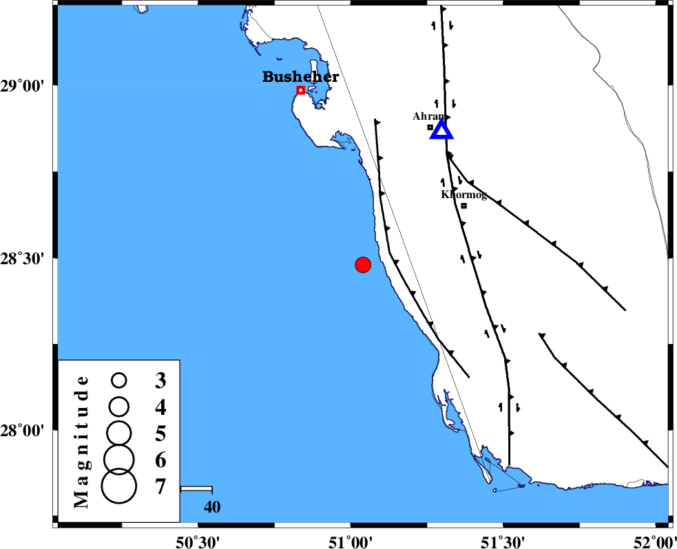
| Location | Lat:28.48 Lon: 51.04 |
| Region | Persian Gulf, 37 km South-West of Khormog |
Nearest Cities |
|
| 24 km South West of Derazi, Bushehr Province | |
| 32 km South of Delvar, Bushehr Province | |
| 34 km South West of Buheyri, Bushehr Province | |
| 38 km South West of Khormog, Bushehr Province | |
| 46 km North West of Baduleh, Bushehr Province | |
| Depth | 18 km |
| Agency | |
Faults within 150 km: |
|
| ZFF2 (Length: 84 km) , Distance to epicenter: 9 km | |
| BORAZJAN_F (Length: 168 km) , Distance to epicenter: 34 km | |
| MFF5 (Length: 74 km) , Distance to epicenter: 43 km | |
| Number of Phases | 4 |
| RMS | 0.1 |
| Number of Stations | 3 |
| Error in Latitude | >12.9 km |
| Error in Longitude | 7.2 km |
| Error in Depth | 11.4 km |
Download waveform in seisan format
to download seisan software Click here
to access information about IIEES stations Click here
Amplitude | ||||||||
| UID | Agency | Station | Component | Amplitude | Period | Arrival Time | Proccessing Time | Signal Clip |
| 31284 | IIEES | GHIR | N | 259.4 | 0.84 | 2004-12-01 06:47:22 | 2006-03-15 11:56:00 | n |
| 31285 | IIEES | GHIR | E | 228.6 | 0.4 | 2004-12-01 06:47:26 | 2006-03-15 11:56:00 | n |
| 31286 | IIEES | KRBR | N | 13 | 0.52 | 2004-12-01 06:48:57 | 2006-03-15 11:56:00 | n |
| 31287 | IIEES | KRBR | E | 11.8 | 0.64 | 2004-12-01 06:49:02 | 2006-03-15 11:56:00 | n |
Phase | ||||||||||||
| Agency | Station | Component | Phase Type | Phase Quality | First Motion | Observed Arrival Time | Time Residual | Loc. Flag | Input Weight | Distance | Azimuth | |
| IIEES | GHIR | Z | PG | E | 2004-12-01 06:46:54 | 0.1 | y | 192 | 96 | |||
| IIEES | GHIR | N | SG | E | 2004-12-01 06:47:17 | 0 | y | 192 | 96 | |||
| IIEES | NASN | Z | PN | E | 2004-12-01 06:47:33 | 0.1 | y | 508 | 19 | |||
| IIEES | KRBR | Z | PN | E | 2004-12-01 06:47:42 | -0.2 | y | 580 | 72 | |||