
Magnitude |
:2.9 |
| Date & Time (UTC) | 2004-11-27 18:51:26.0 |
| Date & Time (Local) | 1383/9/7 22:21:26.0 |
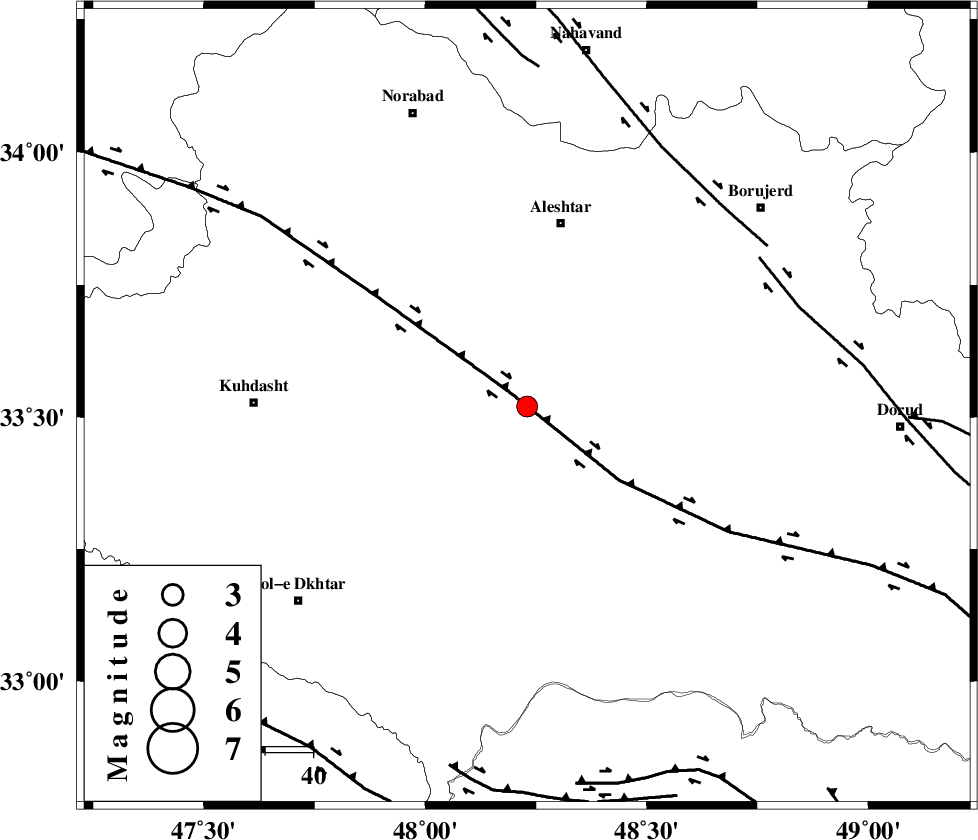
| Location | Lat:33.52 Lon: 48.23 |
| Region | 12 km West of Khorramabad, Lorestan Province |
Nearest Cities |
|
| 11 km North of Godar-e mahmudvand, Lorestan Province | |
| 13 km North West of Khorramabad, Lorestan Province | |
| 14 km North West of Badrabad-e sofla, Lorestan Province | |
| 14 km North of Shoorab-e sofla, Lorestan Province | |
| 15 km West of Rebat namaki, Lorestan Province | |
| Depth | 24 km |
| Agency | |
Faults within 150 km: |
|
| HZF4 (Length: 492 km) , Distance to epicenter: 4 km | |
| DORUD (Length: 100 km) , Distance to epicenter: 58 km | |
| NAHAVAND_F (Length: 102 km) , Distance to epicenter: 59 km | |
| Number of Phases | 4 |
| RMS | 0.1 |
| Number of Stations | 3 |
| Error in Latitude | >0.5 km |
| Error in Longitude | 1.7 km |
| Error in Depth | 0 km |
Download waveform in seisan format
to download seisan software Click here
to access information about IIEES stations Click here
Amplitude | ||||||||
| UID | Agency | Station | Component | Amplitude | Period | Arrival Time | Proccessing Time | Signal Clip |
| 31251 | IIEES | SHGO | E | 142.8 | 0.55 | 2004-11-27 18:52:23 | 2006-03-15 11:56:00 | n |
| 31252 | IIEES | SHGO | N | 245 | 0.65 | 2004-11-27 18:52:25 | 2006-03-15 11:56:00 | n |
| 31253 | IIEES | SNGE | N | 112.4 | 0.56 | 2004-11-27 18:52:34 | 2006-03-15 11:56:00 | n |
Phase | ||||||||||||
| Agency | Station | Component | Phase Type | Phase Quality | First Motion | Observed Arrival Time | Time Residual | Loc. Flag | Input Weight | Distance | Azimuth | |
| IIEES | SHGO | Z | PG | E | 2004-11-27 18:51:52 | 0.1 | y | 165 | 161 | |||
| IIEES | SHGO | N | SG | E | 2004-11-27 18:52:12 | -0.1 | y | 165 | 161 | |||
| IIEES | SNGE | Z | PG | E | 2004-11-27 18:51:57 | 0 | y | 193 | 335 | |||
| IIEES | NASN | Z | PN | E | 2004-11-27 18:52:27 | 0 | y | 434 | 99 | |||