
Magnitude |
:2.5 |
| Date & Time (UTC) | 2004-11-22 22:26:15.9 |
| Date & Time (Local) | 1383/9/3 01:56:15.9 |
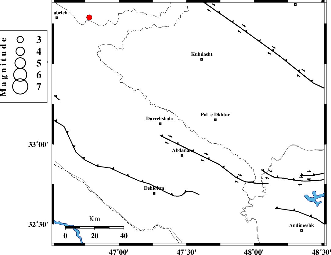
| Location | Lat:33.13 Lon: 47.52 |
| Region | 18 km West of Pol-e dokhtar, Lorestan Province |
Nearest Cities |
|
| 16 km North West of Sarab hammam, Lorestan Province | |
| 17 km South of Chaqabol, Lorestan Province | |
| 18 km East of Dashtabad-e olia, Ilam Province | |
| 18 km West of Pol-e dokhtar, Lorestan Province | |
| 20 km North East of Darreh Shahr, Ilam Province | |
| Depth | 46 km |
| Agency | |
Faults within 150 km: |
|
| BALARUD_F_Z1 (Length: 87 km) , Distance to epicenter: 22 km | |
| MFF6 (Length: 144 km) , Distance to epicenter: 47 km | |
| BALARUD_F_Z3 (Length: 53 km) , Distance to epicenter: 59 km | |
| Number of Phases | 4 |
| RMS | 0.1 |
| Number of Stations | 3 |
| Error in Latitude | >4.9 km |
| Error in Longitude | 14.9 km |
| Error in Depth | 7 km |
Download waveform in seisan format
to download seisan software Click here
to access information about IIEES stations Click here
Amplitude | ||||||||
| UID | Agency | Station | Component | Amplitude | Period | Arrival Time | Proccessing Time | Signal Clip |
| 31196 | IIEES | SHGR | N | 61.7 | 0.29 | 2004-11-22 22:27:12 | 2006-03-15 11:56:00 | n |
| 31197 | IIEES | SHGR | E | 79.7 | 0.48 | 2004-11-22 22:27:15 | 2006-03-15 11:56:00 | n |
| 31198 | IIEES | SNGE | N | 25.8 | 0.51 | 2004-11-22 22:27:26 | 2006-03-15 11:56:00 | n |
| 31199 | IIEES | ASAO | N | 29.4 | 0.4 | 2004-11-22 22:27:29 | 2006-03-15 11:56:00 | n |
| 31200 | IIEES | ASAO | E | 16.9 | 0.64 | 2004-11-22 22:27:38 | 2006-03-15 11:56:00 | n |
Phase | ||||||||||||
| Agency | Station | Component | Phase Type | Phase Quality | First Motion | Observed Arrival Time | Time Residual | Loc. Flag | Input Weight | Distance | Azimuth | |
| IIEES | SHGR | Z | PG | E | 2004-11-22 22:26:43 | 0 | y | 165 | 133 | |||
| IIEES | SNGE | Z | PG | E | 2004-11-22 22:26:51 | -0.1 | y | 219 | 356 | |||
| IIEES | SNGE | N | SG | E | 2004-11-22 22:27:17 | 0.1 | y | 219 | 356 | |||
| IIEES | ASAO | Z | PN | E | 2004-11-22 22:26:55 | 0 | y | 281 | 55 | |||