
Magnitude |
:3.1 |
| Date & Time (UTC) | 2004-11-22 22:22:37.6 |
| Date & Time (Local) | 1383/9/3 01:52:37.6 |
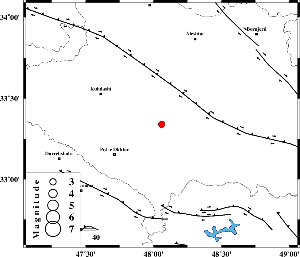
| Location | Lat:33.34 Lon: 48.06 |
| Region | 32 km South-West of Khorramabad, Lorestan Province |
Nearest Cities |
|
| 9 km of Maeulan, Lorestan Province | |
| 14 km West of Shoorab-e sofla, Lorestan Province | |
| 15 km South of Godar-e mahmudvand, Lorestan Province | |
| 17 km South of Mahmudvand, Lorestan Province | |
| 24 km South of Sarabboreh, Lorestan Province | |
| Depth | 16 km |
| Agency | |
Faults within 150 km: |
|
| HZF4 (Length: 492 km) , Distance to epicenter: 26 km | |
| BALARUD_F_Z3 (Length: 53 km) , Distance to epicenter: 56 km | |
| BALARUD_F_Z1 (Length: 87 km) , Distance to epicenter: 60 km | |
| Number of Phases | 6 |
| RMS | 0.2 |
| Number of Stations | 5 |
| Error in Latitude | >2.7 km |
| Error in Longitude | 4.1 km |
| Error in Depth | 6.3 km |
Download waveform in seisan format
to download seisan software Click here
to access information about IIEES stations Click here
Amplitude | ||||||||
| UID | Agency | Station | Component | Amplitude | Period | Arrival Time | Proccessing Time | Signal Clip |
| 31191 | IIEES | SHGR | E | 485.1 | 0.46 | 2004-11-22 22:23:27 | 2006-03-15 11:56:00 | n |
| 31192 | IIEES | SHGR | N | 414.6 | 0.68 | 2004-11-22 22:23:34 | 2006-03-15 11:56:00 | n |
| 31193 | IIEES | SNGE | N | 133.3 | 0.56 | 2004-11-22 22:23:40 | 2006-03-15 11:56:00 | n |
| 31194 | IIEES | ASAO | N | 139.1 | 0.48 | 2004-11-22 22:23:49 | 2006-03-15 11:56:00 | n |
| 31195 | IIEES | ASAO | E | 82 | 0.6 | 2004-11-22 22:23:55 | 2006-03-15 11:56:00 | n |
Phase | ||||||||||||
| Agency | Station | Component | Phase Type | Phase Quality | First Motion | Observed Arrival Time | Time Residual | Loc. Flag | Input Weight | Distance | Azimuth | |
| IIEES | SHGR | Z | PG | E | 2004-11-22 22:23:02 | -0.1 | y | 153 | 153 | |||
| IIEES | SNGE | Z | PG | E | 2004-11-22 22:23:11 | -0.1 | y | 206 | 341 | |||
| IIEES | ASAO | Z | PG | E | 2004-11-22 22:23:15 | 0.4 | y | 226 | 53 | |||
| IIEES | ASAO | E | SG | E | 2004-11-22 22:23:41 | -0.2 | y | 226 | 53 | |||
| IIEES | THKV | Z | PN | E | 2004-11-22 22:23:33 | 0 | y | 385 | 41 | |||
| IIEES | DAMV | Z | PN | E | 2004-11-22 22:23:40 | 0 | y | 440 | 54 | |||