
Magnitude |
:3 |
| Date & Time (UTC) | 2004-11-13 03:18:01.0 |
| Date & Time (Local) | 1383/8/23 06:48:01.0 |
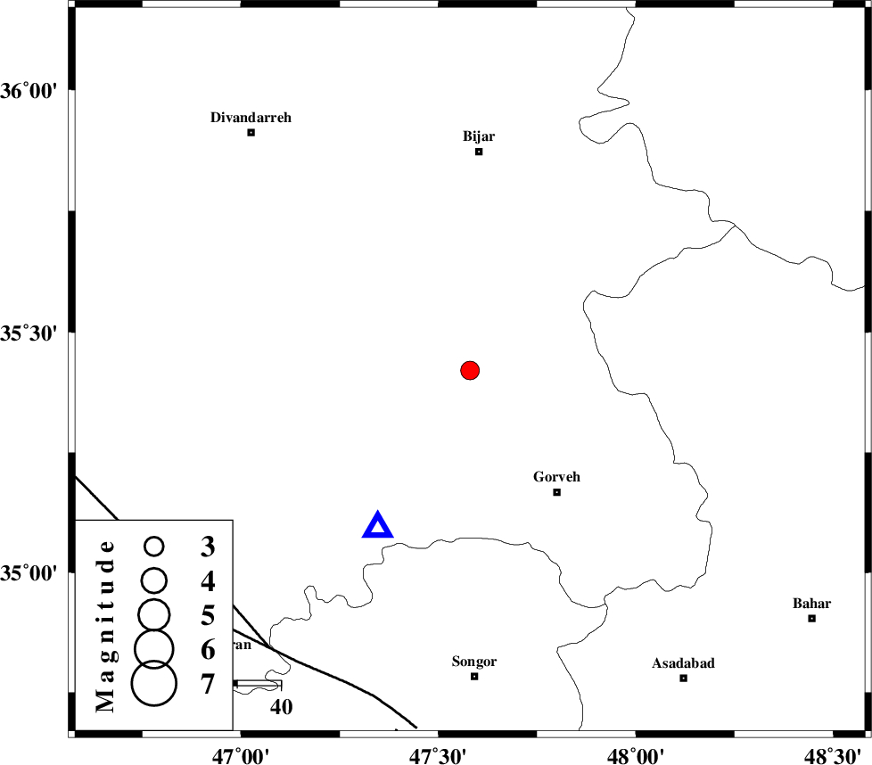
| Location | Lat:35.42 Lon: 47.58 |
| Region | 34 km North-West of Qorveh, Kordestan Province |
Nearest Cities |
|
| 11 km of Khosroabad, Kurdistan Province | |
| 20 km North of Kani ganji, Kurdistan Province | |
| 20 km North East of Dehgolan, Kurdistan Province | |
| 22 km North West of Serishabad, Kurdistan Province | |
| 23 km North East of Hasanabad, Kurdistan Province | |
| Depth | 6 km |
| Agency | |
Faults within 150 km: |
|
| MORVARID_F (Length: 24 km) , Distance to epicenter: 77 km | |
| SARTAKHT_F (Length: 78 km) , Distance to epicenter: 78 km | |
| PIRANSHAHR_F (Length: 253 km) , Distance to epicenter: 81 km | |
| Number of Phases | 5 |
| RMS | 0 |
| Number of Stations | 4 |
| Error in Latitude | >4 km |
| Error in Longitude | 5.4 km |
| Error in Depth | 10.1 km |
Download waveform in seisan format
to download seisan software Click here
to access information about IIEES stations Click here
Amplitude | ||||||||
| UID | Agency | Station | Component | Amplitude | Period | Arrival Time | Proccessing Time | Signal Clip |
| 30928 | IIEES | SNGE | N | 1457.1 | 0.21 | 2004-11-13 03:18:15 | 2006-03-15 11:56:00 | n |
| 30929 | IIEES | THKV | E | 56.3 | 0.63 | 2004-11-13 03:19:33 | 2006-03-15 11:56:00 | n |
| 30930 | IIEES | THKV | N | 62.9 | 0.48 | 2004-11-13 03:19:34 | 2006-03-15 11:56:00 | n |
Phase | ||||||||||||
| Agency | Station | Component | Phase Type | Phase Quality | First Motion | Observed Arrival Time | Time Residual | Loc. Flag | Input Weight | Distance | Azimuth | |
| IIEES | SNGE | Z | PG | E | 2004-11-13 03:18:08 | 0 | y | 42.3 | 210 | |||
| IIEES | SNGE | N | SG | E | 2004-11-13 03:18:14 | 0 | y | 42.3 | 210 | |||
| IIEES | THKV | Z | PN | E | 2004-11-13 03:18:47 | 0 | y | 304 | 79 | |||
| IIEES | GRMI | Z | PN | E | 2004-11-13 03:18:56 | 0 | y | 377 | 4 | |||
| IIEES | DAMV | Z | PN | E | 2004-11-13 03:18:59 | 0 | y | 399 | 85 | |||