
Magnitude |
:3.8 |
| Date & Time (UTC) | 2004-11-10 04:44:29.0 |
| Date & Time (Local) | 1383/8/20 08:14:29.0 |
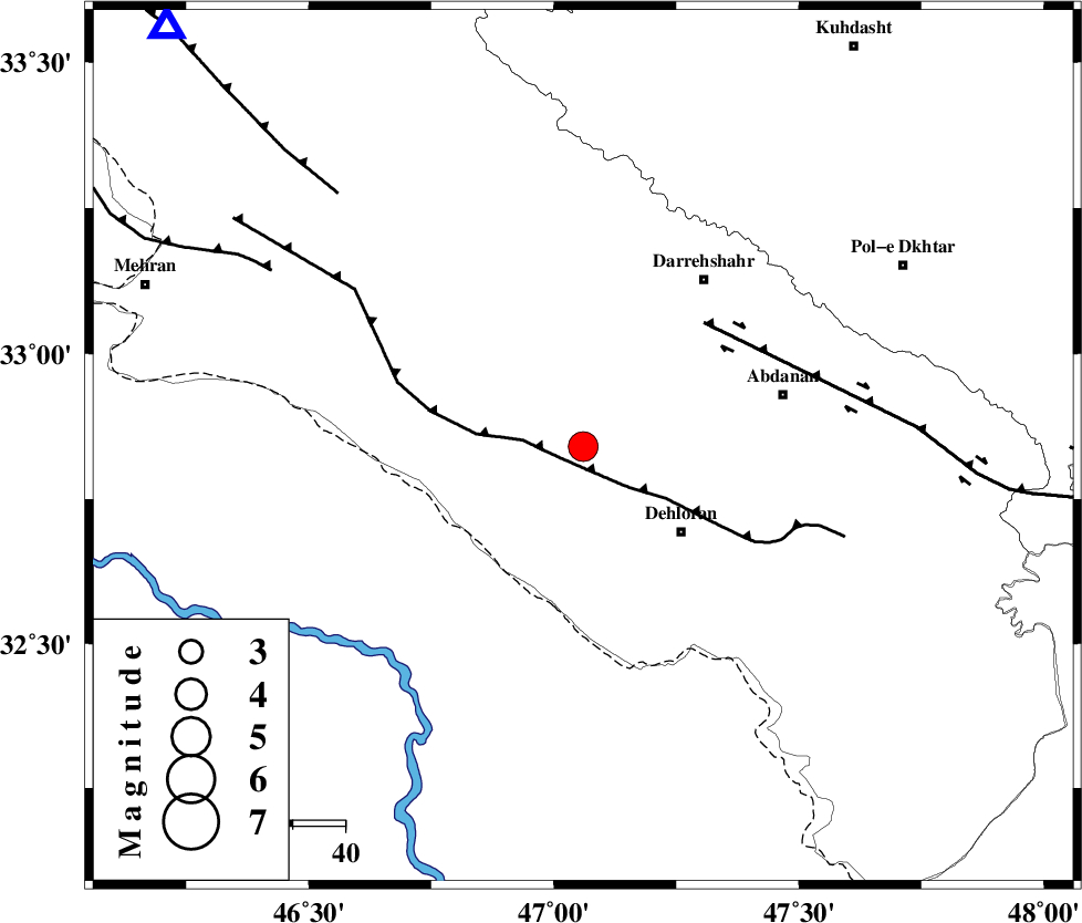
| Location | Lat:32.84 Lon: 47.06 |
| Region | 25 km North-West of Dehloran, Ilam Province |
Nearest Cities |
|
| 8 km North of Bishehzar, Ilam Province | |
| 25 km North West of Dehloran, Ilam Province | |
| 39 km South West of Darreh Shahr, Ilam Province | |
| 39 km West of Abdanan, Ilam Province | |
| 43 km North West of Musian, Ilam Province | |
| Depth | 35 km |
| Agency | |
Faults within 150 km: |
|
| MFF6 (Length: 144 km) , Distance to epicenter: 5 km | |
| BALARUD_F_Z1 (Length: 87 km) , Distance to epicenter: 33 km | |
| MFF7 (Length: 99 km) , Distance to epicenter: 67 km | |
| Number of Phases | 5 |
| RMS | 0.1 |
| Number of Stations | 5 |
| Error in Latitude | >4.9 km |
| Error in Longitude | 7.9 km |
| Error in Depth | 7.7 km |
Download waveform in seisan format
to download seisan software Click here
to access information about IIEES stations Click here
Amplitude | ||||||||
| UID | Agency | Station | Component | Amplitude | Period | Arrival Time | Proccessing Time | Signal Clip |
| 30860 | IIEES | SHGR | E | 1999.4 | 0.85 | 2004-11-10 04:45:29 | 2006-03-15 11:56:00 | n |
| 30861 | IIEES | SHGR | N | 1701.1 | 0.44 | 2004-11-10 04:45:31 | 2006-03-15 11:56:00 | n |
| 30862 | IIEES | SNGE | N | 284.9 | 0.58 | 2004-11-10 04:45:39 | 2006-03-15 11:56:00 | n |
| 30863 | IIEES | DAMV | E | 67.1 | 0.62 | 2004-11-10 04:46:54 | 2006-03-15 11:56:00 | n |
| 30864 | IIEES | DAMV | N | 46 | 0.69 | 2004-11-10 04:46:54 | 2006-03-15 11:56:00 | n |
Phase | ||||||||||||
| Agency | Station | Component | Phase Type | Phase Quality | First Motion | Observed Arrival Time | Time Residual | Loc. Flag | Input Weight | Distance | Azimuth | |
| IIEES | SHGR | Z | PG | E | 2004-11-10 04:44:58 | 0.1 | y | 183 | 116 | |||
| IIEES | SHGR | E | SG | E | 2004-11-10 04:45:20 | -0.1 | y | 183 | 116 | |||
| IIEES | SNGE | Z | PN | E | 2004-11-10 04:45:06 | -0.1 | y | 251 | 6 | |||
| IIEES | THKV | Z | PN | E | 2004-11-10 04:45:35 | 0.1 | y | 490 | 45 | |||
| IIEES | GHIR | Z | PN | E | 2004-11-10 04:46:09 | 0 | y | 760 | 130 | |||