
Magnitude |
:2.4 |
| Date & Time (UTC) | 2004-10-28 23:21:36.5 |
| Date & Time (Local) | 1383/8/8 02:51:36.5 |
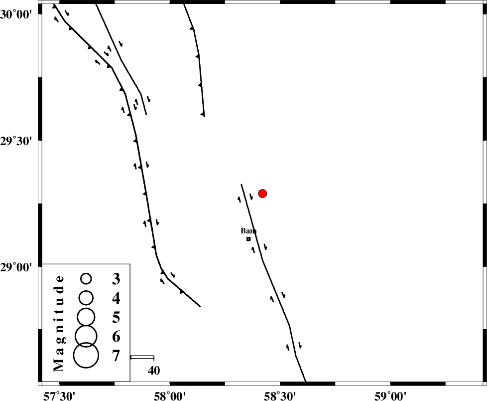
| Location | Lat:29.29 Lon: 58.42 |
| Region | 21 km North of Bam, Kerman Province |
Nearest Cities |
|
| 18 km North of Poshtrud, Kerman Province | |
| 21 km North of Bam, Kerman Province | |
| 27 km North of Baravat, Kerman Province | |
| 43 km North West of Qasemabad, Kerman Province | |
| 44 km North West of Abshur-e nezamabad, Kerman Province | |
| Depth | 14 km |
| Agency | |
Faults within 150 km: |
|
| BAM_F (Length: 118 km) , Distance to epicenter: 10 km | |
| SHAHDAD_F (Length: 108 km) , Distance to epicenter: 42 km | |
| GOWK_F (Length: 152 km) , Distance to epicenter: 51 km | |
| Number of Phases | 4 |
| RMS | 0 |
| Number of Stations | 3 |
| Error in Latitude | >16.4 km |
| Error in Longitude | 4.2 km |
| Error in Depth | 26.7 km |
Download waveform in seisan format
to download seisan software Click here
to access information about IIEES stations Click here
Amplitude | ||||||||
| UID | Agency | Station | Component | Amplitude | Period | Arrival Time | Proccessing Time | Signal Clip |
| 30727 | IIEES | KRBR | N | 91 | 0.29 | 2004-10-28 23:22:28 | 2006-03-15 11:56:00 | n |
| 30728 | IIEES | KRBR | E | 125.8 | 0.21 | 2004-10-28 23:22:29 | 2006-03-15 11:56:00 | n |
| 30729 | IIEES | ZHSF | N | 11.2 | 0.28 | 2004-10-28 23:22:47 | 2006-03-15 11:56:00 | n |
| 30730 | IIEES | ZHSF | E | 10.7 | 0.51 | 2004-10-28 23:22:48 | 2006-03-15 11:56:00 | n |
| 30731 | IIEES | BNDS | N | 11.3 | 0.66 | 2004-10-28 23:23:03 | 2006-03-15 11:56:00 | n |
Phase | ||||||||||||
| Agency | Station | Component | Phase Type | Phase Quality | First Motion | Observed Arrival Time | Time Residual | Loc. Flag | Input Weight | Distance | Azimuth | |
| IIEES | KRBR | Z | PG | E | 2004-10-28 23:22:06 | 0 | y | 178 | 296 | |||
| IIEES | KRBR | E | SG | E | 2004-10-28 23:22:27 | 0 | y | 178 | 296 | |||
| IIEES | ZHSF | Z | PG | E | 2004-10-28 23:22:14 | 0 | y | 231 | 81 | |||
| IIEES | BNDS | Z | PN | E | 2004-10-28 23:22:22 | 0 | y | 304 | 227 | |||