
Magnitude |
:2.8 |
| Date & Time (UTC) | 2004-10-18 06:42:18.4 |
| Date & Time (Local) | 1383/7/27 10:12:18.4 |
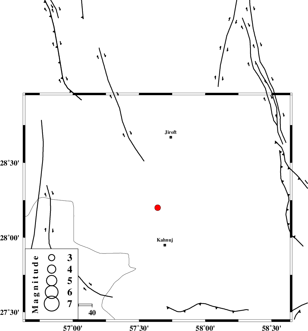
| Location | Lat:28.2 Lon: 57.64 |
| Region | 27 km North of Kahnuj, Kerman Province |
Nearest Cities |
|
| 9 km of Bolock, Kerman Province | |
| 26 km North East of Mehrueye-e paeen, Kerman Province | |
| 28 km North of Kahnuj, Kerman Province | |
| 32 km North East of Hurpasefid, Kerman Province | |
| 35 km South West of Aliabad-e qadiri, Kerman Province | |
| Depth | 14 km |
| Agency | |
Faults within 150 km: |
|
| SABZEVARAN_F (Length: 190 km) , Distance to epicenter: 13 km | |
| JIROFT_F (Length: 144 km) , Distance to epicenter: 22 km | |
| MAIN_ZAGROS_R_F (Length: 1106 km) , Distance to epicenter: 79 km | |
| Number of Phases | 5 |
| RMS | 0.6 |
| Number of Stations | 4 |
| Error in Latitude | >11 km |
| Error in Longitude | 14.7 km |
| Error in Depth | 20.8 km |
Download waveform in seisan format
to download seisan software Click here
to access information about IIEES stations Click here
Amplitude | ||||||||
| UID | Agency | Station | Component | Amplitude | Period | Arrival Time | Proccessing Time | Signal Clip |
| 30606 | IIEES | BNDS | E | 149.1 | 0.41 | 2004-10-18 06:43:08 | 2006-03-15 11:56:00 | n |
| 30607 | IIEES | BNDS | N | 136.6 | 0.4 | 2004-10-18 06:43:10 | 2006-03-15 11:56:00 | n |
| 30608 | IIEES | KRBR | E | 70.2 | 0.29 | 2004-10-18 06:43:27 | 2006-03-15 11:56:00 | n |
| 30609 | IIEES | KRBR | N | 57.3 | 0.26 | 2004-10-18 06:43:29 | 2006-03-15 11:56:00 | n |
Phase | ||||||||||||
| Agency | Station | Component | Phase Type | Phase Quality | First Motion | Observed Arrival Time | Time Residual | Loc. Flag | Input Weight | Distance | Azimuth | |
| IIEES | BNDS | Z | PG | E | 2004-10-18 06:42:46 | 0.1 | y | 169 | 239 | |||
| IIEES | BNDS | E | SG | E | 2004-10-18 06:43:06 | -0.4 | y | 169 | 239 | |||
| IIEES | KRBR | Z | PG | E | 2004-10-18 06:42:53 | -0.4 | y | 216 | 337 | |||
| IIEES | ZHSF | Z | PN | E | 2004-10-18 06:43:08 | -0.2 | y | 344 | 62 | |||
| IIEES | GHIR | Z | PN | E | 2004-10-18 06:43:24 | 1.2 | y | 456 | 272 | |||