
Magnitude |
:3.7 |
| Date & Time (UTC) | 2004-10-09 14:48:38.7 |
| Date & Time (Local) | 1383/7/18 18:18:38.7 |
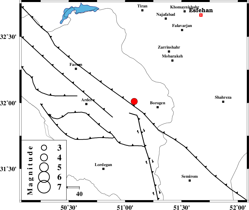
| Location | Lat:32.01 Lon: 51.08 |
| Region | 20 km West of Borujen, Chaharmahal Bakhtiari Province |
Nearest Cities |
|
| 9 km North of Baladaji, Chaharmahal Bakhtiari Province | |
| 11 km North West of Faradonbeh, Chaharmahal Bakhtiari Province | |
| 16 km South of Sefid-dasht, Chaharmahal Bakhtiari Province | |
| 18 km North of Gandoman, Chaharmahal Bakhtiari Province | |
| 20 km North West of Borujen, Chaharmahal Bakhtiari Province | |
| Depth | 15 km |
| Agency | |
Faults within 150 km: |
|
| DENA_F (Length: 137 km) , Distance to epicenter: 11 km | |
| MAIN_ZAGROS_R_F (Length: 1106 km) , Distance to epicenter: 12 km | |
| ARDAL_F (Length: 170 km) , Distance to epicenter: 22 km | |
| Number of Phases | 8 |
| RMS | 0.7 |
| Number of Stations | 6 |
| Error in Latitude | >11.2 km |
| Error in Longitude | 5.7 km |
| Error in Depth | 13.4 km |
Download waveform in seisan format
to download seisan software Click here
to access information about IIEES stations Click here
Amplitude | ||||||||
| UID | Agency | Station | Component | Amplitude | Period | Arrival Time | Proccessing Time | Signal Clip |
| 30467 | IIEES | SHGR | N | 628.8 | 0.8 | 2004-10-09 14:49:48 | 2006-03-15 11:56:00 | n |
| 30468 | IIEES | SHGR | E | 684.7 | 0.66 | 2004-10-09 14:49:53 | 2006-03-15 11:56:00 | n |
| 30469 | IIEES | ASAO | N | 319.3 | 0.68 | 2004-10-09 14:50:24 | 2006-03-15 11:56:00 | n |
| 30470 | IIEES | ASAO | E | 249.1 | 0.76 | 2004-10-09 14:50:27 | 2006-03-15 11:56:00 | n |
Phase | ||||||||||||
| Agency | Station | Component | Phase Type | Phase Quality | First Motion | Observed Arrival Time | Time Residual | Loc. Flag | Input Weight | Distance | Azimuth | |
| IIEES | NASN | Z | PG | E | 2004-10-09 14:49:08 | -0.7 | y | 185 | 61 | |||
| IIEES | NASN | N | SG | E | 2004-10-09 14:49:31 | 0.1 | y | 185 | 61 | |||
| IIEES | SHGR | Z | PG | E | 2004-10-09 14:49:12 | -1.2 | y | 215 | 274 | |||
| IIEES | SHGR | N | SG | E | 2004-10-09 14:49:40 | 0.6 | y | 215 | 274 | |||
| IIEES | ASAO | Z | PN | E | 2004-10-09 14:49:23 | 0.2 | y | 298 | 341 | |||
| IIEES | DAMV | Z | PN | E | 2004-10-09 14:49:38 | 1 | y | 410 | 11 | |||
| IIEES | GHIR | Z | PN | E | 2004-10-09 14:49:43 | 0.6 | y | 452 | 155 | |||
| IIEES | SNGE | Z | PN | E | 2004-10-09 14:49:46 | -0.3 | y | 487 | 316 | |||