
Magnitude |
:3.3 |
| Date & Time (UTC) | 2004-09-14 23:11:23.4 |
| Date & Time (Local) | 1383/6/25 03:41:23.4 |
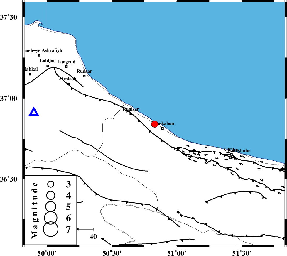
| Location | Lat:36.84 Lon: 50.83 |
| Region | 5 km Tonekabon, Mazandaran Province |
Nearest Cities |
|
| 5 km North of Soleymanabad, Mazandaran Province | |
| 6 km North of Tonekabon, Mazandaran Province | |
| 8 km North of Khorramabad, Mazandaran Province | |
| 18 km East of Ramsar, Mazandaran Province | |
| 18 km North West of Kanza, Mazandaran Province | |
| Depth | 6 km |
| Agency | |
Faults within 150 km: |
|
| KHAZAR_F (Length: 523 km) , Distance to epicenter: 6 km | |
| N_ALBORZ_F (Length: 360 km) , Distance to epicenter: 20 km | |
| BONAN_F (Length: 74 km) , Distance to epicenter: 33 km | |
| Number of Phases | 5 |
| RMS | 0.1 |
| Number of Stations | 4 |
| Error in Latitude | >3.2 km |
| Error in Longitude | 5.4 km |
| Error in Depth | 6.5 km |
Download waveform in seisan format
to download seisan software Click here
to access information about IIEES stations Click here
Amplitude | ||||||||
| UID | Agency | Station | Component | Amplitude | Period | Arrival Time | Proccessing Time | Signal Clip |
| 28109 | IIEES | THKV | E | 1734.1 | 0.32 | 2004-09-14 23:11:55 | 2006-03-15 11:56:00 | n |
| 28110 | IIEES | THKV | N | 2265.5 | 0.44 | 2004-09-14 23:11:55 | 2006-03-15 11:56:00 | n |
| 28111 | IIEES | ASAO | E | 64.6 | 0.4 | 2004-09-14 23:12:39 | 2006-03-15 11:56:00 | n |
| 28112 | IIEES | ASAO | N | 78.2 | 0.32 | 2004-09-14 23:12:40 | 2006-03-15 11:56:00 | n |
Phase | ||||||||||||
| Agency | Station | Component | Phase Type | Phase Quality | First Motion | Observed Arrival Time | Time Residual | Loc. Flag | Input Weight | Distance | Azimuth | |
| IIEES | THKV | Z | PG | E | 2004-09-14 23:11:41 | -0.1 | y | 102 | 178 | |||
| IIEES | THKV | E | SG | E | 2004-09-14 23:11:54 | 0 | y | 102 | 178 | |||
| IIEES | DAMV | Z | PG | E | 2004-09-14 23:11:52 | 0 | y | 169 | 142 | |||
| IIEES | ASAO | Z | PN | E | 2004-09-14 23:12:05 | -0.1 | y | 264 | 196 | |||
| IIEES | SNGE | Z | PN | E | 2004-09-14 23:12:18 | 0.1 | y | 369 | 239 | |||