
Magnitude |
:3.7 |
| Date & Time (UTC) | 2004-07-02 12:56:39.9 |
| Date & Time (Local) | 1383/4/12 17:26:39.9 |
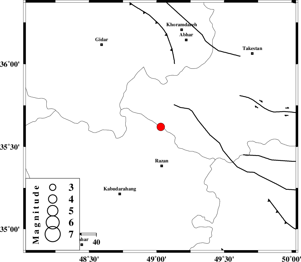
| Location | Lat:35.62 Lon: 49.03 |
| Region | 25 km North of Razan, Hamedan Province |
Nearest Cities |
|
| 19 km North West of Avaj, Ghazvin Province | |
| 24 km North East of Khorandeh, Hamedan Province | |
| 26 km North of Razan, Hamedan Province | |
| 27 km North East of Damag, Hamedan Province | |
| 28 km South West of Ab-e garm, Ghazvin Province | |
| Depth | 14 km |
| Agency | |
Faults within 150 km: |
|
| KUSHK_E_NOSRAT_F (Length: 230 km) , Distance to epicenter: 17 km | |
| SOLTANIYEH_F (Length: 119 km) , Distance to epicenter: 43 km | |
| IPAK_F (Length: 80 km) , Distance to epicenter: 57 km | |
| Number of Phases | 5 |
| RMS | 0.4 |
| Number of Stations | 3 |
| Error in Latitude | >11.3 km |
| Error in Longitude | 14.9 km |
| Error in Depth | 19 km |
Download waveform in seisan format
to download seisan software Click here
to access information about IIEES stations Click here
Amplitude | ||||||||
| UID | Agency | Station | Component | Amplitude | Period | Arrival Time | Proccessing Time | Signal Clip |
| 28022 | IIEES | ASAO | N | 1168.3 | 0.44 | 2004-07-02 12:57:29 | 2006-03-15 11:56:00 | n |
| 28023 | IIEES | DAMV | N | 888.4 | 0.64 | 2004-07-02 12:58:02 | 2006-03-15 11:56:00 | n |
| 28024 | IIEES | NASN | N | 44.7 | 0.64 | 2004-07-02 12:58:03 | 2006-03-15 11:56:00 | n |
Phase | ||||||||||||
| Agency | Station | Component | Phase Type | Phase Quality | First Motion | Observed Arrival Time | Time Residual | Loc. Flag | Input Weight | Distance | Azimuth | |
| IIEES | ASAO | Z | PG | E | 2004-07-02 12:57:04 | -0.6 | y | 149 | 142 | |||
| IIEES | DAMV | Z | PN | E | 2004-07-02 12:57:20 | 0 | y | 267 | 89 | |||
| IIEES | DAMV | N | SG | E | 2004-07-02 12:57:55 | -0.1 | y | 267 | 89 | |||
| IIEES | NASN | Z | PN | E | 2004-07-02 12:57:46 | 0.7 | y | 468 | 131 | |||
| IIEES | NASN | E | SG | E | 2004-07-02 12:58:50 | 0.2 | y | 468 | 131 | |||