
Magnitude |
:2.9 |
| Date & Time (UTC) | 2005-05-19 08:10:25.5 |
| Date & Time (Local) | 1384/2/29 12:40:25.5 |
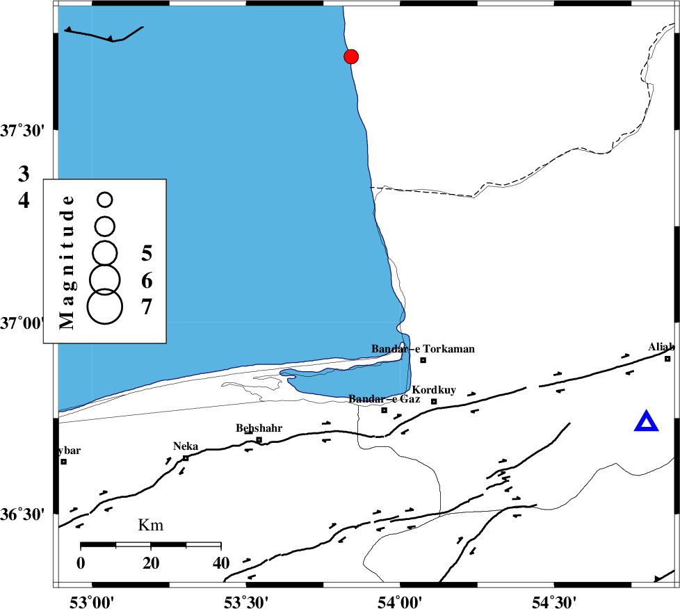
| Location | Lat:37.07 Lon: 53.89 |
| Region | |
Nearest Cities |
|
| 17 km West of Gomishtappeh, Golestan Province | |
| 25 km North West of Bandar-e torkaman, Golestan Province | |
| 29 km North West of Sijval, Golestan Province | |
| 31 km North West of Banavar, Golestan Province | |
| 34 km North of Bandar-e gaz, Golestan Province | |
| Depth | 14 km |
| Agency | |
Faults within 150 km: |
|
| KHAZAR_F (Length: 523 km) , Distance to epicenter: 37 km | |
| N_ALBORZ_F (Length: 360 km) , Distance to epicenter: 63 km | |
| SHAVAR_F (Length: 87 km) , Distance to epicenter: 72 km | |
| Number of Phases | 5 |
| RMS | 0.2 |
| Number of Stations | 3 |
| Error in Latitude | >13.1 km |
| Error in Longitude | 10.6 km |
| Error in Depth | 12 km |
Download waveform in seisan format
to download seisan software Click here
to access information about IIEES stations Click here
Amplitude | ||||||||
| UID | Agency | Station | Component | Amplitude | Period | Arrival Time | Proccessing Time | Signal Clip |
| 5816 | IIEES | DAMV | E | 158.1 | 0.34 | 2005-05-19 08:11:39 | 2005-07-05 05:11:00 | n |
| 5817 | IIEES | ASAO | N | 9.6 | 0.4 | 2005-05-19 08:12:38 | 2005-07-05 05:11:00 | n |
Phase | ||||||||||||
| Agency | Station | Component | Phase Type | Phase Quality | First Motion | Observed Arrival Time | Time Residual | Loc. Flag | Input Weight | Distance | Azimuth | |
| IIEES | DAMV | Z | PG | E | 2005-05-19 08:11:03 | -0.1 | y | 235.1 | 228 | |||
| IIEES | DAMV | N | SG | E | 2005-05-19 08:11:32 | 0.1 | y | 235.1 | 228 | |||
| IIEES | THR | Z | PN | E | 2005-05-19 08:11:08 | 0.4 | y | 279.3 | 243 | |||
| IIEES | THR | N | SG | E | 2005-05-19 08:11:44 | -0.1 | y | 279.3 | 243 | |||
| IIEES | ASAO | Z | PN | E | 2005-05-19 08:11:28 | -0.3 | y | 447.6 | 232 | |||