
Magnitude |
:3.1 |
| Date & Time (UTC) | 2005-05-02 03:21:10.3 |
| Date & Time (Local) | 1384/2/12 07:51:10.3 |
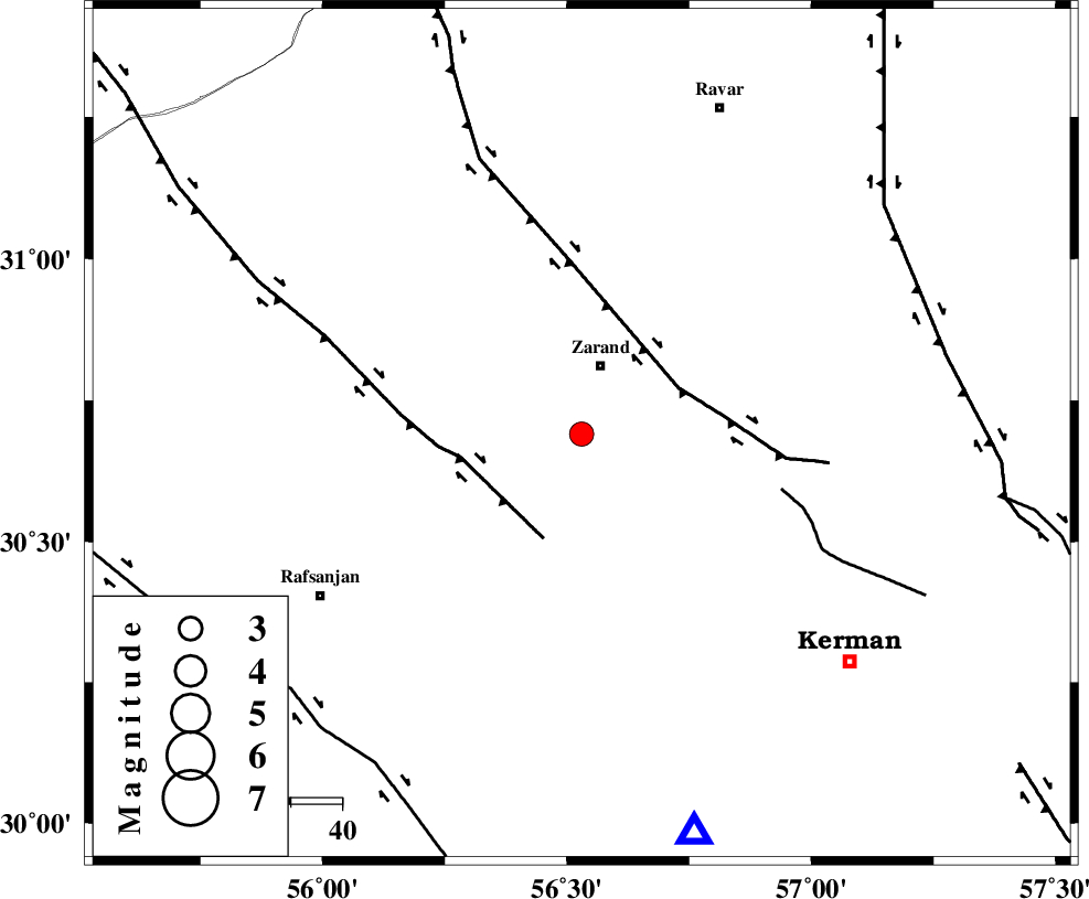
| Location | Lat:30.69 Lon: 56.53 |
| Region | |
Nearest Cities |
|
| 10 km of Mohammadabad, Kerman Province | |
| 12 km West of Bahaabad, Kerman Province | |
| 14 km South of Zarand, Kerman Province | |
| 20 km North East of Jorjanak, Kerman Province | |
| 25 km West of Khankuk, Kerman Province | |
| Depth | 14 km |
| Agency | |
Faults within 150 km: |
|
| KUHBANAN_F (Length: 189 km) , Distance to epicenter: 21 km | |
| DARIVAN_F (Length: 131 km) , Distance to epicenter: 22 km | |
| CHATRUD_F (Length: 37 km) , Distance to epicenter: 40 km | |
| Number of Phases | 4 |
| RMS | 0 |
| Number of Stations | 3 |
| Error in Latitude | >6.2 km |
| Error in Longitude | 9.1 km |
| Error in Depth | 3.8 km |
Download waveform in seisan format
to download seisan software Click here
to access information about IIEES stations Click here
Amplitude | ||||||||
| UID | Agency | Station | Component | Amplitude | Period | Arrival Time | Proccessing Time | Signal Clip |
| 5641 | IIEES | KRBR | N | 883.1 | 0.16 | 2005-05-02 03:21:39 | 2005-07-05 05:11:00 | n |
| 5642 | IIEES | BNDS | N | 26.8 | 0.52 | 2005-05-02 03:23:11 | 2005-07-05 05:11:00 | n |
| 5643 | IIEES | NASN | N | 34.3 | 0.44 | 2005-05-02 03:23:24 | 2005-07-05 05:11:00 | n |
Phase | ||||||||||||
| Agency | Station | Component | Phase Type | Phase Quality | First Motion | Observed Arrival Time | Time Residual | Loc. Flag | Input Weight | Distance | Azimuth | |
| IIEES | KRBR | Z | PG | E | 2005-05-02 03:21:24 | 0 | y | 81.42 | 164 | |||
| IIEES | BNDS | Z | PN | E | 2005-05-02 03:22:03 | 0 | y | 366.3 | 186 | |||
| IIEES | NASN | Z | PN | E | 2005-05-02 03:22:10 | 0 | y | 423.3 | 305 | |||
| IIEES | NASN | N | SG | E | 2005-05-02 03:23:08 | 0 | y | 423.3 | 305 | |||