
Magnitude |
:2.2 |
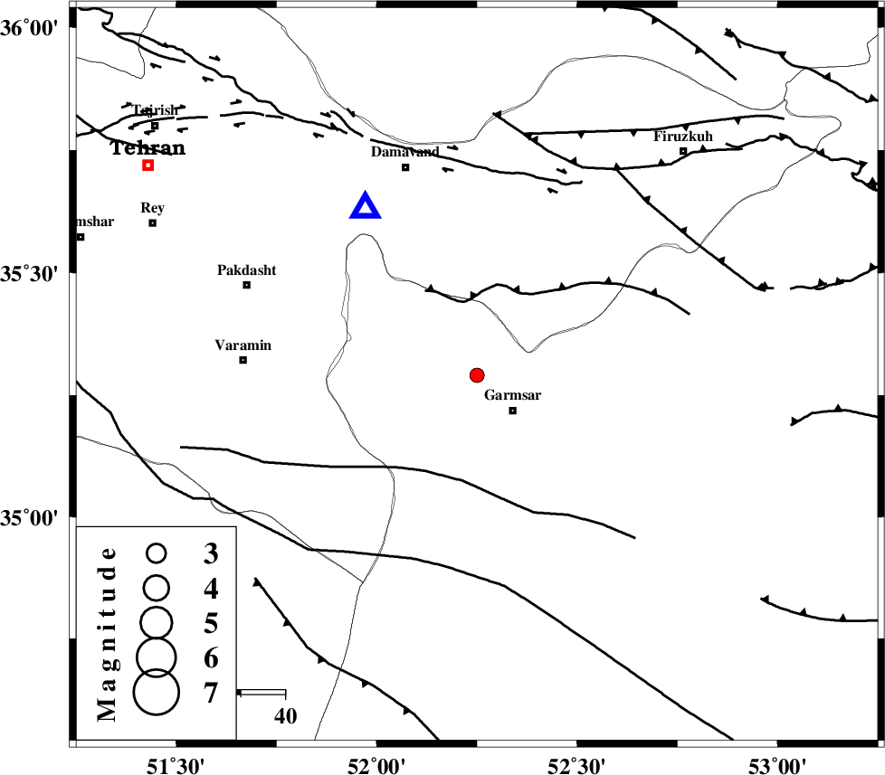
| Date & Time (UTC) | 2005-04-24 12:50:33.6 |
| Date & Time (Local) | 1384/2/4 17:20:33.6 |
| Location | Lat:35.29 Lon: 52.25 |
| Region | |
Nearest Cities |
|
| 11 km North of Garmsar, Semnan Province | |
| 13 km North of Lajran, Semnan Province | |
| 18 km East of Evanekay, Semnan Province | |
| 20 km North West of Gardovan, Semnan Province | |
| 22 km North West of Davarabad, Semnan Province | |
| Depth | 34 km |
| Agency | |
Faults within 150 km: |
|
| GARMSAR_F (Length: 77 km) , Distance to epicenter: 5 km | |
| EYVANEKEY_F (Length: 74 km) , Distance to epicenter: 6 km | |
| PISHAV_F (Length: 34 km) , Distance to epicenter: 31 km | |
| Number of Phases | 8 |
| RMS | 0.3 |
| Number of Stations | 5 |
| Error in Latitude | >4 km |
| Error in Longitude | 7 km |
| Error in Depth | 6 km |
Download waveform in seisan format
to download seisan software Click here
to access information about IIEES stations Click here
Amplitude | ||||||||
| UID | Agency | Station | Component | Amplitude | Period | Arrival Time | Proccessing Time | Signal Clip |
| 5570 | IIEES | DAMV | N | 186.8 | 0.44 | 2005-04-24 12:50:59 | 2005-07-05 05:11:00 | n |
| 5571 | IIEES | ASAO | N | 19.2 | 0.32 | 2005-04-24 12:51:38 | 2005-07-05 05:11:00 | n |
Phase | ||||||||||||
| Agency | Station | Component | Phase Type | Phase Quality | First Motion | Observed Arrival Time | Time Residual | Loc. Flag | Input Weight | Distance | Azimuth | |
| IIEES | DAMV | Z | PG | E | 2005-04-24 12:50:42 | -0.5 | y | 45.19 | 326 | |||
| IIEES | DAMV | E | SG | E | 2005-04-24 12:50:50 | 0.2 | y | 45.19 | 326 | |||
| IIEES | THR | Z | PG | E | 2005-04-24 12:50:54 | 0.1 | y | 122.7 | 304 | |||
| IIEES | THR | E | SG | E | 2005-04-24 12:51:09 | 0.1 | y | 122.7 | 304 | |||
| IIEES | THKV | Z | PG | E | 2005-04-24 12:50:57 | 0.3 | y | 142.3 | 299 | |||
| IIEES | ASAO | Z | PG | E | 2005-04-24 12:51:08 | -0.4 | y | 219.6 | 249 | |||
| IIEES | NASN | Z | PN | E | 2005-04-24 12:51:14 | 0 | y | 281.4 | 169 | |||
| IIEES | NASN | E | SG | E | 2005-04-24 12:51:51 | 0.2 | y | 281.4 | 169 | |||