
Magnitude |
:3.4 |
| Date & Time (UTC) | 2005-03-07 04:23:10.5 |
| Date & Time (Local) | 1383/12/17 07:53:10.5 |
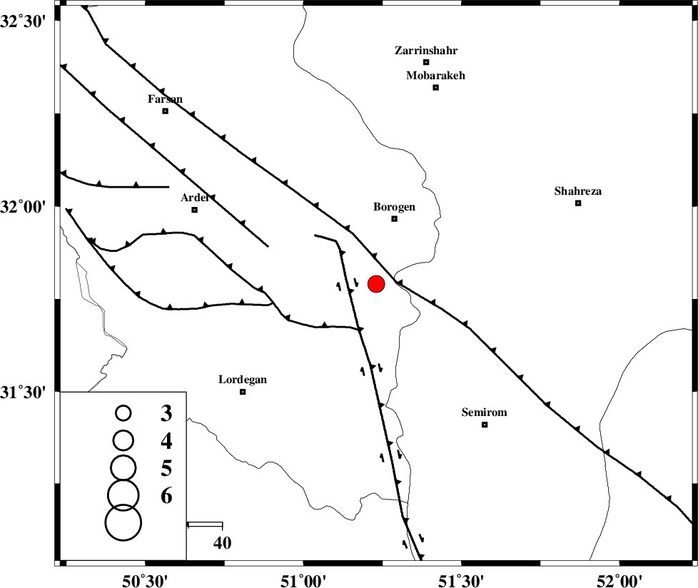
| Location | Lat:31.79 Lon: 51.23 |
| Region | |
Nearest Cities |
|
| 11 km of Gandoman, Chaharmahal Bakhtiari Province | |
| 20 km South of Borujen, Chaharmahal Bakhtiari Province | |
| 23 km South East of Baladaji, Chaharmahal Bakhtiari Province | |
| 24 km South of Faradonbeh, Chaharmahal Bakhtiari Province | |
| 26 km South West of Hamgin, Esfahan Province | |
| Depth | 14 km |
| Agency | |
Faults within 150 km: |
|
| MAIN_ZAGROS_R_F (Length: 1106 km) , Distance to epicenter: 6 km | |
| DENA_F (Length: 137 km) , Distance to epicenter: 9 km | |
| DOPOLAN_F (Length: 107 km) , Distance to epicenter: 15 km | |
| Number of Phases | 9 |
| RMS | 0.4 |
| Number of Stations | 7 |
| Error in Latitude | >4.2 km |
| Error in Longitude | 4.1 km |
| Error in Depth | 8.8 km |
Download waveform in seisan format
to download seisan software Click here
to access information about IIEES stations Click here
Amplitude | ||||||||
| UID | Agency | Station | Component | Amplitude | Period | Arrival Time | Proccessing Time | Signal Clip |
| 5204 | IIEES | SHGR | N | 330.7 | 0.68 | 2005-03-07 04:24:39 | 2005-07-05 05:11:00 | n |
| 5205 | IIEES | SHGO | N | 184 | 0.6 | 2005-03-07 04:24:33 | 2005-07-05 05:11:00 | n |
| 5206 | IIEES | ASAO | N | 113.3 | 0.72 | 2005-03-07 04:24:54 | 2005-07-05 05:11:00 | n |
| 5207 | IIEES | SNGE | N | 27.4 | 0.68 | 2005-03-07 04:25:58 | 2005-07-05 05:11:00 | n |
Phase | ||||||||||||
| Agency | Station | Component | Phase Type | Phase Quality | First Motion | Observed Arrival Time | Time Residual | Loc. Flag | Input Weight | Distance | Azimuth | |
| IIEES | NASN | Z | PG | E | 2005-03-07 04:23:41 | -0.1 | y | 186.6 | 53 | |||
| IIEES | SHGO | Z | PG | E | 2005-03-07 04:23:47 | -0.5 | y | 231.9 | 279 | |||
| IIEES | SHGR | Z | PG | E | 2005-03-07 04:23:47 | -0.5 | y | 231.9 | 279 | |||
| IIEES | SHGR | N | SG | E | 2005-03-07 04:24:16 | 0.5 | y | 231.9 | 279 | |||
| IIEES | ASAO | Z | PN | E | 2005-03-07 04:23:59 | 0.3 | y | 326 | 340 | |||
| IIEES | ASAO | E | SG | E | 2005-03-07 04:24:42 | -0.2 | y | 326 | 340 | |||
| IIEES | GHIR | Z | PN | E | 2005-03-07 04:24:11 | 0.1 | y | 423.6 | 156 | |||
| IIEES | DAMV | Z | PN | E | 2005-03-07 04:24:12 | 0.3 | y | 431.9 | 9 | |||
| IIEES | SNGE | Z | PN | E | 2005-03-07 04:24:22 | 0.3 | y | 514.2 | 317 | |||