
Magnitude |
:2.4 |
| Date & Time (UTC) | 2005-02-16 21:06:01.2 |
| Date & Time (Local) | 1383/11/29 00:36:01.2 |
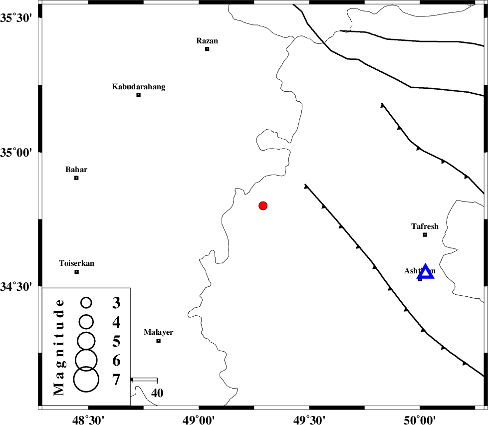
| Location | Lat:34.8 Lon: 49.29 |
| Region | |
Nearest Cities |
|
| 5 km North of Komijan, Markazi Province | |
| 10 km of Vafs, Markazi Province | |
| 15 km North of Khosrobeyk, Markazi Province | |
| 21 km North of Safandan, Markazi Province | |
| 23 km North West of Khanjin, Markazi Province | |
| Depth | 14 km |
| Agency | |
Faults within 150 km: |
|
| TAFRESH_F (Length: 117 km) , Distance to epicenter: 19 km | |
| INDES_F (Length: 98 km) , Distance to epicenter: 65 km | |
| KUSHK_E_NOSRAT_F (Length: 230 km) , Distance to epicenter: 70 km | |
| Number of Phases | 6 |
| RMS | 0.2 |
| Number of Stations | 4 |
| Error in Latitude | >4.6 km |
| Error in Longitude | 2.9 km |
| Error in Depth | 7.3 km |
Download waveform in seisan format
to download seisan software Click here
to access information about IIEES stations Click here
Amplitude | ||||||||
| UID | Agency | Station | Component | Amplitude | Period | Arrival Time | Proccessing Time | Signal Clip |
| 4789 | IIEES | ASAO | E | 241.2 | 0.11 | 2005-02-16 21:06:24 | 2005-07-05 05:11:00 | n |
| 4790 | IIEES | SNGE | N | 42.1 | 0.29 | 2005-02-16 21:06:58 | 2005-07-05 05:11:00 | n |
| 4791 | IIEES | DAMV | N | 27.6 | 0.32 | 2005-02-16 21:07:17 | 2005-07-05 05:11:00 | n |
| 4792 | IIEES | NASN | N | 4.2 | 0.45 | 2005-02-16 21:08:08 | 2005-07-05 05:11:00 | n |
Phase | ||||||||||||
| Agency | Station | Component | Phase Type | Phase Quality | First Motion | Observed Arrival Time | Time Residual | Loc. Flag | Input Weight | Distance | Azimuth | |
| IIEES | ASAO | Z | PG | E | 2005-02-16 21:06:14 | 0.3 | y | 73 | 112 | |||
| IIEES | ASAO | E | SG | E | 2005-02-16 21:06:23 | -0.2 | y | 73 | 112 | |||
| IIEES | SNGE | Z | PG | E | 2005-02-16 21:06:30 | -0.2 | y | 180.3 | 281 | |||
| IIEES | DAMV | Z | PN | E | 2005-02-16 21:06:41 | 0.3 | y | 261.1 | 69 | |||
| IIEES | DAMV | N | SG | E | 2005-02-16 21:07:14 | -0.2 | y | 261.1 | 69 | |||
| IIEES | NASN | Z | PN | E | 2005-02-16 21:06:58 | -0.1 | y | 394.1 | 123 | |||