
Magnitude |
:3.1 |
| Date & Time (UTC) | 2005-06-20 22:23:35.8 |
| Date & Time (Local) | 1384/3/31 02:53:35.8 |
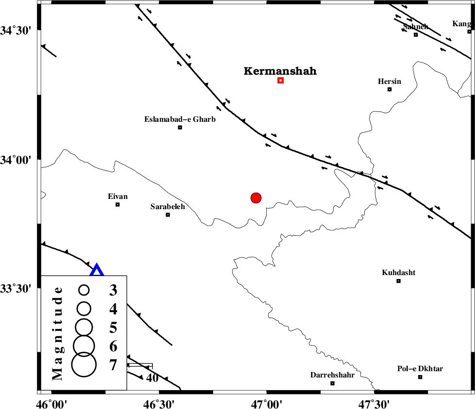
| Location | Lat:33.85 Lon: 46.95 |
| Region | |
Nearest Cities |
|
| 8 km of Qale-ye harsam, Kermanshah Province | |
| 15 km East of Darbid-e mansuri, Kermanshah Province | |
| 18 km West of Chenar, Kermanshah Province | |
| 19 km East of Hamil, Kermanshah Province | |
| 23 km South West of Buzhan, Kermanshah Province | |
| Depth | 14 km |
| Agency | |
Faults within 150 km: |
|
| HZF4 (Length: 492 km) , Distance to epicenter: 25 km | |
| MFF7 (Length: 99 km) , Distance to epicenter: 72 km | |
| MFF6 (Length: 144 km) , Distance to epicenter: 89 km | |
| Number of Phases | 5 |
| RMS | 0.1 |
| Number of Stations | 4 |
| Error in Latitude | >2 km |
| Error in Longitude | 14.4 km |
| Error in Depth | 6.4 km |
Download waveform in seisan format
to download seisan software Click here
to access information about IIEES stations Click here
Amplitude | ||||||||
| UID | Agency | Station | Component | Amplitude | Period | Arrival Time | Proccessing Time | Signal Clip |
| 4303 | IIEES | SNGE | N | 531.7 | 0.56 | 2005-06-20 22:24:19 | 2005-07-05 05:11:00 | n |
| 4304 | IIEES | SHGR | Z | 86 | 0.64 | 2005-06-20 22:25:19 | 2005-07-05 05:11:00 | n |
| 4305 | IIEES | ASAO | N | 72.8 | 0.56 | 2005-06-20 22:25:02 | 2005-07-05 05:11:00 | n |
Phase | ||||||||||||
| Agency | Station | Component | Phase Type | Phase Quality | First Motion | Observed Arrival Time | Time Residual | Loc. Flag | Input Weight | Distance | Azimuth | |
| IIEES | SNGE | Z | PG | E | 2005-06-20 22:23:59 | 0.1 | y | 142.3 | 15 | |||
| IIEES | SNGE | E | SG | E | 2005-06-20 22:24:16 | -0.1 | y | 142.3 | 15 | |||
| IIEES | SHGR | Z | PG | E | 2005-06-20 22:24:18 | 0 | y | 259.4 | 138 | |||
| IIEES | SHGO | Z | PG | E | 2005-06-20 22:24:18 | 0 | y | 259.4 | 138 | |||
| IIEES | ASAO | Z | PN | E | 2005-06-20 22:24:20 | 0.1 | y | 293.6 | 74 | |||